
Summary
Look at the towers first. Then seek the path of the water. Reading Angkor as more than a single temple reveals a landscape shaped by water, labour and belief. A shoreline photograph, a dated satellite image and scientific studies offer three different windows onto its history.
Through the reflection, into the city
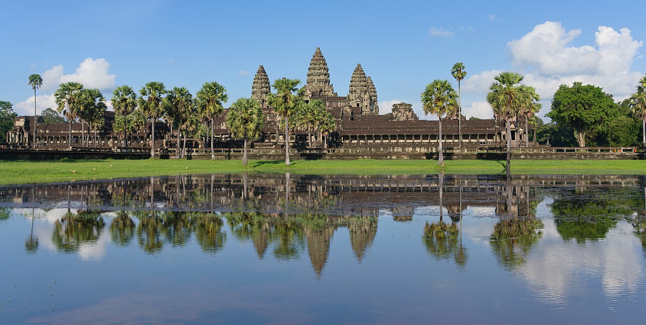
The first thing you notice is the line of towers against the sky. A few seconds later your gaze drops: the same building appears again in the water. You could read this photograph simply as a beautiful reflection. Put the water at the beginning of the story, however, and another city begins to emerge. Alongside the stone holding up the towers, the arrangements sustaining life around them become objects of curiosity.
Angkor brings together successive capitals of the Khmer kingdom, temples and an extensive cultural landscape in Cambodia. UNESCO’s description includes ponds, embankments, reservoirs, canals and roads alongside monuments. Treating Angkor Wat as the whole of Angkor is rather like looking at a city through its most famous room. Life continues beyond the frame. [1]
Your first discovery task is simple: what would this image lose without the water? Begin with what you can see: reflection, shoreline, passage and distance. Then widen the question. Who needed to know where water would be available, and when? A question beginning in front of a temple can carry us into a much larger landscape.
The labour hidden inside a rectangle
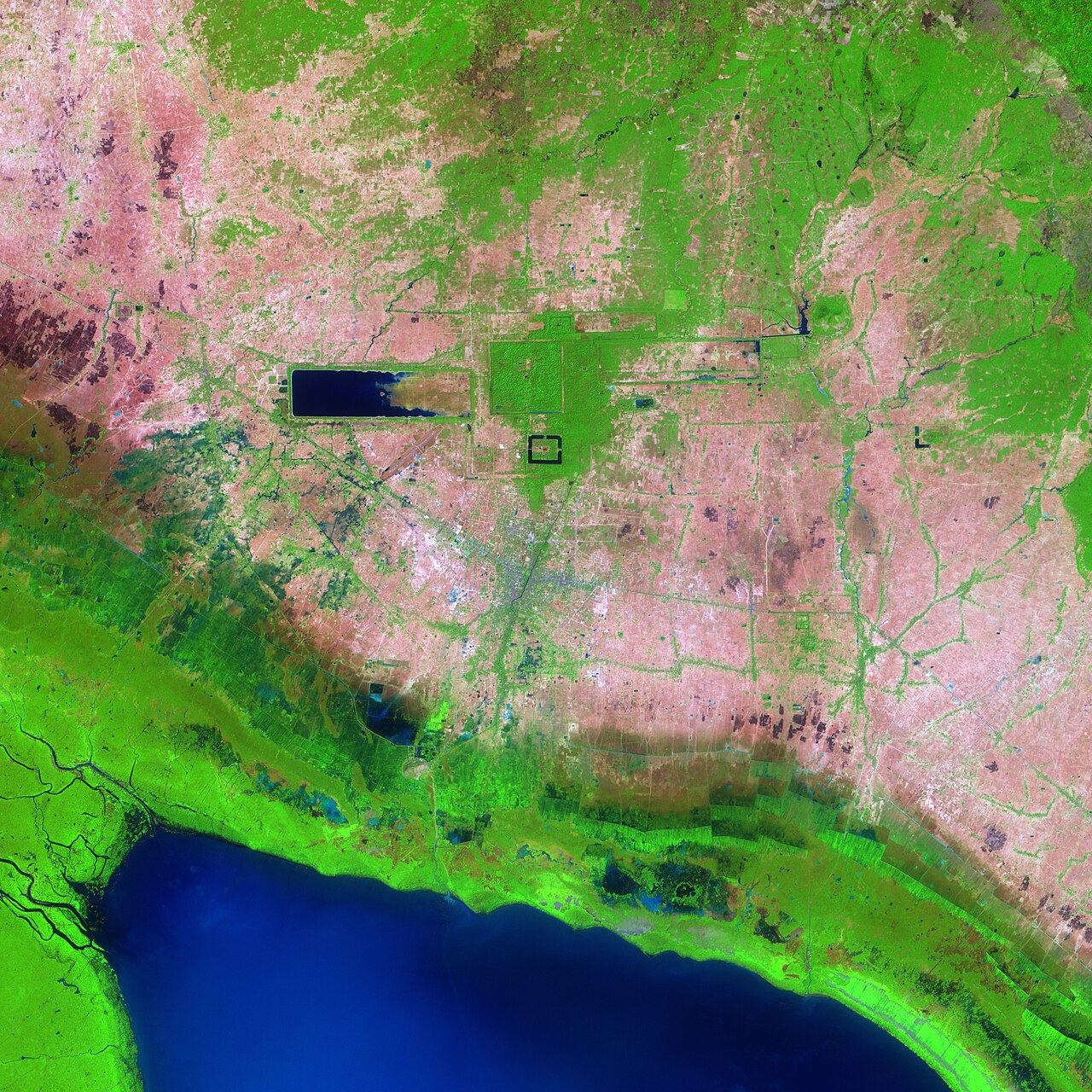
In the satellite image, the rhythm of the city changes. Details of carved stone disappear and large geometries take their place. West Baray is the conspicuous rectangular water surface. NASA’s Terra/ASTER image, acquired on 17 February 2004, lets us compare Angkor Wat, Angkor Thom and the great reservoirs within one view. Its simulated natural colours are a presentation of sensor data, rather than an ordinary photograph taken from an aircraft that day. [2]
A baray is a large reservoir. Yet a ruler alone cannot describe its scale. Forming a bank, managing entrances and outlets, and attending to accumulating material require continuing work. The straight line visible today represents more than a decision made once: it points towards a relationship that had to be maintained. Maintenance is one of the unseen protagonists in a reservoir’s story.
Day and colleagues studied an approximately two-metre sediment core from West Baray to build a long environmental record. Published in 2012, the research examines evidence of use and management from construction in the early eleventh century through the thirteenth. It relates later changes in deposition to water management, land use and climate. When water recedes, more than the shore becomes visible: material accumulating below also becomes a source for research. [3]
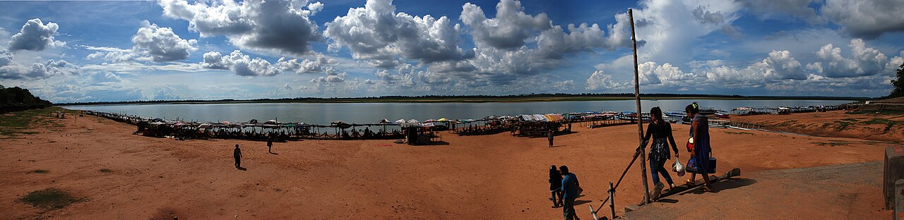
Now move closer to the shoreline photograph. Seen from above, the same place is a shape; from the bank, it becomes a distance. Looking towards the far water, add another question beside “How large is it?” Ask what had to happen for this arrangement to keep working. The question leads from the appearance of a monument towards the history of labour.
Too little water, then too much
A city’s water problem is not always a shortage. Heavy rainfall following a long dry period can also put a system under strain. Buckley and colleagues’ 2010 study examines prolonged droughts and powerful monsoons in the fourteenth and fifteenth centuries through a regional climate reconstruction from tree rings. It considers climatic variability as one contributing factor in Angkor’s transformation. [4]
In 2018, Penny and colleagues turned archaeological evidence of the water network into a numerical model. It shows how erosion and sedimentation during flooding could generate cascading problems across connected infrastructure. A change at one point affecting other points is central to the study. This is a model result, not a record of one storm silencing an entire city overnight. [5]
Follow a waterway in your imagination. If a passage upstream becomes blocked, does the land below receive the same supply? If the flow turns elsewhere, which bank might the new route erode? These are questions for thinking with this story. They do not replace a detailed engineering calculation, but they help us stop treating a city as a collection of independent buildings.
Here the tension grows: connections providing strength can also share vulnerability when something goes wrong. Even so, climate alone is too narrow an explanation for Angkor’s long history. Retaining the researchers’ idea of a contribution allows room for a wider history that also includes political and social changes.
Two languages of water
Reading water only as a substance to store would also leave something out. Musée Guimet’s account of the group of giants from Preah Khan explains the figures flanking a causeway across the moats. Deva and asura pulling a cobra’s body evoke the Churning of the Ocean of Milk. This belongs to water’s religious and symbolic world; it is not a technical explanation of how the canals worked. [6]
Two different questions can stand beside each other in one landscape. Someone asking where water goes follows flow, gradient and connections. Someone asking what a causeway conveys examines the arrangement of sculptures and the meaning of a myth. Distinguishing these questions does not diminish either one. It helps reveal why the same place can be so rich.
Angkor remains a living heritage landscape. UNESCO describes villages, farming, rituals and local communities as part of life around the monuments. The image of a completely empty city lost in the forest cannot tell the whole story. [1] Return one last time to the opening reflection. You are now thinking about shores, connections, seasons and the people sustaining that arrangement as well as towers. Seeing an image for a second time can be one of a historical journey’s most powerful moments.
Explore the same place at three scales.
Let each view open a different question.
01 / What is in the frame?
Describe the relationship between water and building in the opening photograph. Can this single picture show the whole city’s water arrangements?
Return to the reflection ↑02 / What appears from a distance?
Find the large rectangular reservoir in the satellite image. Compare it with the shoreline photograph: what is visible in one view and lost in the other?
Compare the two views ↑03 / What does a connection change?
Explain in your own words how a blocked canal might affect land downstream. Then distinguish a model result from a historical document.
Return to the network ↑A landscape’s long timeline
- Ninth–fifteenth centuries
The Angkor region accommodates successive Khmer capitals and major building programmes. [1]
- Early eleventh century
Construction of West Baray: the starting period examined in the 2012 environmental study. [3]
- Early twelfth century
Angkor Wat is built during the reign of Suryavarman II. [2]
- Fourteenth–fifteenth centuries
Research examines prolonged droughts and intense monsoons among the factors in urban transformation. [4]
- 1992
Angkor enters the UNESCO World Heritage List. [1]
- 2004
Angkor leaves the List of World Heritage in Danger. The ASTER image on this page was also acquired in 2004. [1][2]
- 2012 and 2018
Sediment records and infrastructure-network models open different scientific windows onto the history of water management. [3][5]
Evidence, myth and interpretation
Documented landscape
Angkor’s cultural landscape includes reservoirs, embankments and canals as well as temples. Scientific studies examine climate and infrastructure together. [1][4][5]
The world of myth
The Churning of the Ocean of Milk is a religious narrative. Its relationship to the Preah Khan causeway sculptures does not substitute for a history of engineering. [6]
From the image to the wider landscape
UNESCO’s Angkor video page provides films credited to UNESCO TV / © TBS and UNESCO TV / © NHK Nippon Hoso Kyokai. Watch them on their own source page.
Open UNESCO’s Angkor film page ↗
No Geçmişin Haritası film is currently attached to this story. Third-party footage has not been copied. External playback and English narration or subtitles have not been verified.
Draw a waterway. Choose a question.
Compare photograph and satellite view, separating observation from interpretation. In the final task, read Angkor alongside Petra or Istanbul’s water structures.
Open the free discovery card ↗Follow the story’s sources
- UNESCO World Heritage · Angkor
- NASA Earth Observatory · Angkor Ruins, 2004 image
- Day and colleagues · Paleoenvironmental history of the West Baray, PNAS 2012
- Buckley and colleagues · Climate as a contributing factor in the demise of Angkor, PNAS 2010
- Penny and colleagues · Systemic vulnerability of urban infrastructure to climatic variations, Science Advances 2018
- Musée Guimet · The Giants’ Causeway, Preah Khan
- UNESCO · Official Angkor film sources
Complete English edition of all four current Turkish chapters and the accompanying discovery tasks. Source and licence review: 25 October 2026. Research is identified by publication year and archive imagery by acquisition or photograph date. Original narrative: Geçmişin Haritası.
More doors opened by water
Hampi: Water through a stone city — story in Turkish ↗
Tikal: Water quality and forest traces — story in Turkish ↗
Petra: A channel beside the rock ↗ · Istanbul’s underground water memory ↗ · Karnak: Ritual and labour ↗
Explore reading files and existing collections ↗