The route
Change the carrier. A caravan road can connect with a river and a maritime network without making its inland city a port.
 GEÇMİŞİN
PALMYRA / SYRIA
Follow a load, meet a face and read the date beneath an arch. Palmyra’s story reaches far beyond the desert horizon.
4 readings · 3 licensed images · 10 source records
Follow route, person and record ↓ · Free discovery card ↗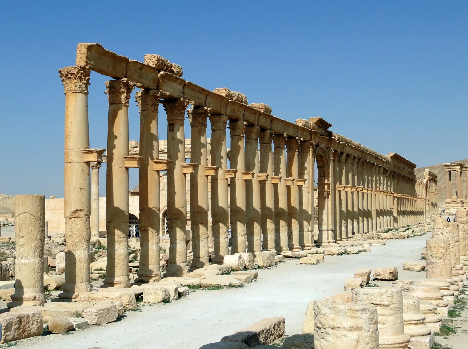
A bracket on a column, a name beside a carved face and a photograph taken before destruction: three small details open a large city. Read Palmyra through its connections to river and sea, its people and the records that keep changing places in view.
Change the carrier. A caravan road can connect with a river and a maritime network without making its inland city a port.
Move from the long street to one face. Keep the museum’s object date separate from the photograph’s unknown date.
Read the date before imagining the present. A 2010 view and a 2015 destruction notice answer different questions.
READING 01
The road seems to pull the eye towards the right edge of the photograph. Columns repeat; their shadows break the pale ground into intervals. Tiny visitors in the distance give the stone a human scale. Before following the road, look halfway up the nearest columns. Short blocks project from their shafts, like shelves waiting for something to return. The most useful beginning may be this modest interruption in an impressive view.
Getty’s monument record identifies these brackets as supports for bronze statues. Inscriptions attached public remembrance to named people and civic groups. The street therefore carried more than movement: it displayed recognition. Its apparently continuous line also hides time. Different sections were built over more than a century, rather than in one finished campaign. A repeated architectural form need not mean a single moment or a single patron. [2]
UNESCO describes a meeting of Greco-Roman building techniques, local traditions and Persian influences. That makes a single cultural label an awkward fit for the whole city. Let the column begin a question about exchange, rather than end it with a label. Who was honoured here, and what contribution or relationship did an inscription make visible? [1]
Bernard Gagnon made this photograph on 7 April 2010. It records visible remains on that day, not a complete ancient street. Imagine the missing statues as a research question, not as an exact reconstruction. Notice how the empty bracket changes your reading: the grand avenue becomes a place where people once argued, through monuments, for a lasting place in public memory.
READING 02
There is no sea in the opening photograph. Palmyra was inland. Yet stopping at the dry horizon would cut its story short. Picture a load whose journey cannot be completed by one carrier. At some point it must be moved, counted or handed over. The line on a map is smooth; the work behind it is made of separate stages. Follow those changes and the desert city begins to face the water.
In her Getty research essay, Joan Aruz explains the route scholars reconstruct from caravan and trading evidence: camels crossed from Palmyra towards the Euphrates, probably near Hit; goods then travelled downstream towards ports connected with Indian maritime networks. Land, river and sea belonged to a linked journey. This is a reconstruction from evidence, not a surviving itinerary for every consignment. [4]
A bilingual tariff dated 137 CE illuminates regulation and local transactions. Honorific inscriptions for caravan leaders and supporters provide another kind of evidence for longer connections. Getty treats these records together; the tariff alone is not a complete inventory of distant commerce. One stone helps us ask about charges, another about cooperation and recognition. Their questions overlap without becoming identical. [3]
On your card, give the load three stops rather than one arrow. Write where the carrier changes, then leave space for the source that supports that connection. The exercise is deliberately small. It replaces an effortless journey with a sequence of decisions. Behind a monumental street, we can begin to recognise the less visible labour of keeping people, goods and information moving between places.
READING 03
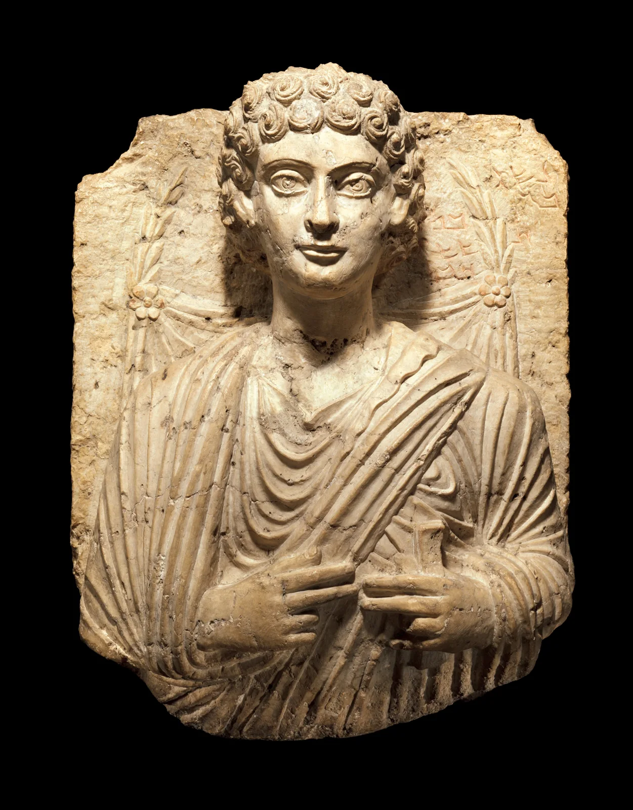
The second image brings the distance close. Here are curls, broad eyes, folded cloth and carefully placed hands. The street invited us to imagine a crowd; the relief offers one chosen appearance within it. Let your eye move slowly from the face to the writing beside it. A person and a name occupy the same stone. The scale of the story has changed, but the desire to be remembered has not.
The Met dates this limestone funerary relief, object 2012.454, to about 125–150 CE. Its record explains that Palmyrene Aramaic writing gives a name and lineage. The small object in the left hand is described as probably a book roll. That probability matters: it is not a licence to assign a definite occupation. The object’s ancient date is also different from the unspecified date of its modern photograph. [5]
Look again without supplying a biography. Which detail did you notice first: the eyes, the hand or the letters? Write that observation before adding the museum’s explanation. An impression of calm is not proof of temperament; a carefully presented garment does not disclose every part of a life. The portrait can remain compelling while our questions stay open. It asks us to look closely, not to pretend we have met its subject.
The same discipline helps when we turn to the famous Queen Zenobia. Judith Weingarten’s Getty essay contrasts contemporary coins with the much later, strongly biased Historia Augusta. The existence of the ruler and the reliability of every later story are different questions. Getty’s historical overview also separates Aurelian’s intervention in 272 from the suppression of a second rebellion in 273. Neither episode erased all subsequent life at Palmyra. [6], [3]
READING 04
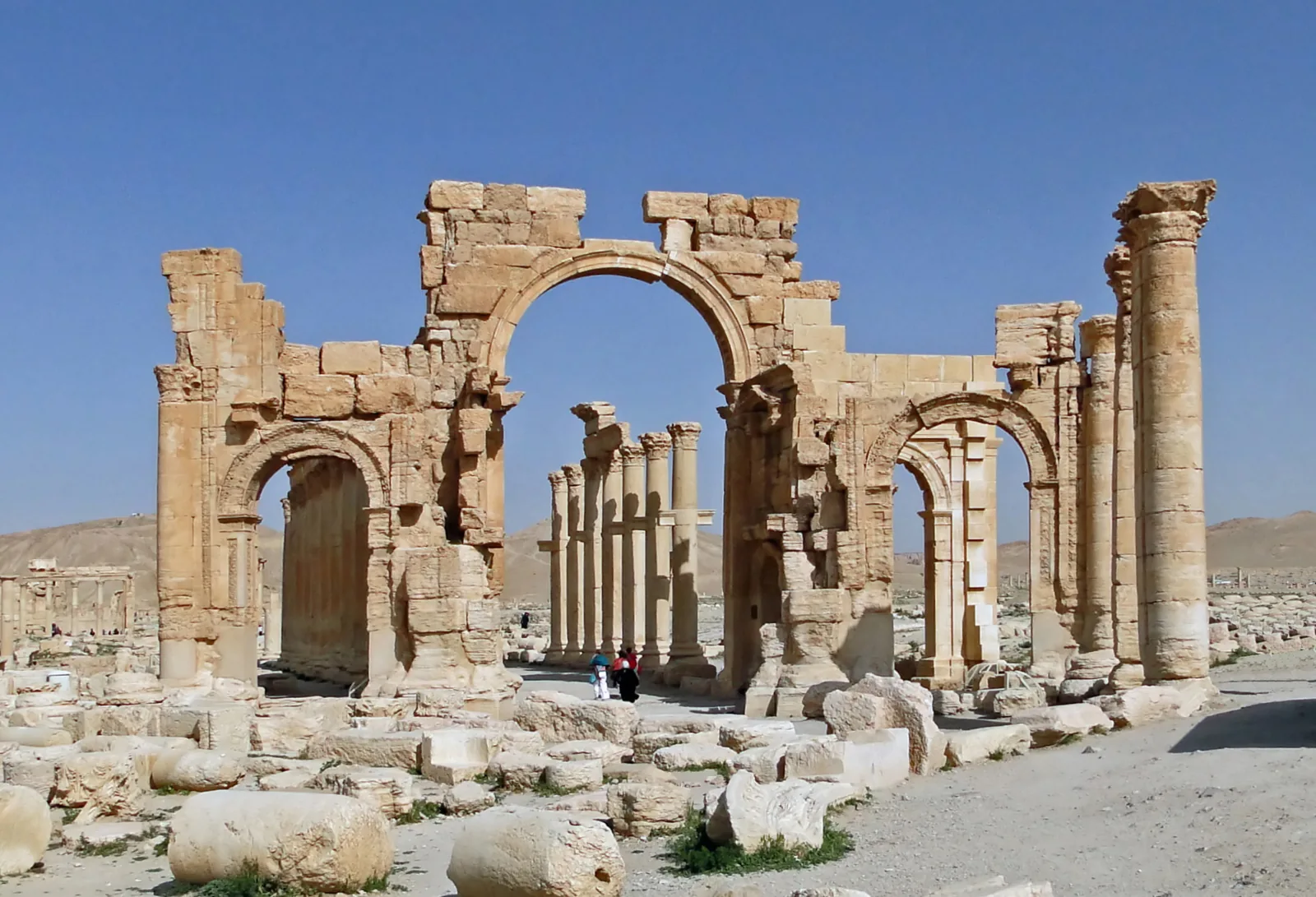
Two visitors stand beneath the arch’s large opening. Columns behind them lead the gaze back into the city. Gagnon took this view on 7 April 2010 as well. The date is not a decorative line below a beautiful image. It tells us which moment we are allowed to describe. A photograph can travel unchanged through years in which the place itself changes profoundly.
UNESCO’s notice of 5 October 2015 records the destruction of the monumental arch. Read that publication beside the photograph and the distinction becomes clear: the image is a dated record of the earlier structure, not evidence that it stands in the same form now. The date of the notice is not, by itself, a timestamp for the act of destruction. [7]
On 27 April 2016, UNESCO reported preliminary damage observations from its 24–26 April mission. Matching and documenting broken sculptural fragments had begun. The work described was a process, not a declaration that everything had been restored. In October 2025, a further UNESCO notice introduced a map bringing together archaeological and heritage interventions by different teams. Documentation has dates and purposes of its own. [8], [9]
Return to the three details before closing the story. A bracket prompts a question about public recognition; a face brings a person into view; a dated photograph helps us read change. None can contain the whole city. Together, they offer a way to remember Palmyra through connections and people as well as monuments. Choose one detail, name the record that helps explain it, and carry that question into your next reading.
Three ways to separate a visible detail from its interpretation. This is a reading guide, not an exact itinerary or a reconstruction of today’s site.
Visible: The street photograph shows a land route; neither river nor sea is visible.
Interpreted: Aruz connects caravan travel to Euphrates transport and maritime networks. This is a scholarly route reconstruction.
Source 4 ↗Visible: Hands, clothing, curls and an inscription share one relief.
Interpreted: The Met supplies object context and a tentative identification of the small object as a book roll.
Source 5 ↗Visible: The arch photograph was taken on 7 April 2010.
Interpreted: The 5 October 2015 UNESCO notice documents later destruction; neither record establishes today’s visitor conditions.
Source 7 ↗Getty identifies supports for bronze statues. Start with the visible shelf, then ask whose name and contribution a neighbouring inscription recorded. [2]
The museum says probably a book roll. Keep that qualification when you write your own caption; do not turn it into a certain profession. [5]
A view from 2010 precedes UNESCO’s 2015 destruction notice. Read the two records together without treating the photograph as a current site report. [7]
Yes. Getty describes a colonnade built in sections over more than a century. A continuous view can conceal different phases. [2]
No. The 137 CE tariff and caravan honour inscriptions illuminate different aspects of the city’s economy. Read them as complementary evidence. [3]
Palmyra was inland. It belonged to networks involving caravan, river and maritime transport; this does not place a harbour beside the photographed street. [4]
Zenobia is historically attested. Contemporary coin evidence and a later biased narrative should not be treated as interchangeable witnesses. [6]
Getty’s overview describes continued habitation in later periods. Damage and reduced prominence are not the same as the end of all human life at the site. [3]
The Met’s date for funerary relief 2012.454. This is an object date, not a photograph date. [5]
Date of the bilingual tariff, one part of the evidence for Palmyra’s regulated economy. [3]
Aurelian’s intervention and a second intervention following another rebellion: distinct episodes. [3]
Palmyra is inscribed on the UNESCO World Heritage List. [1]
Publication of UNESCO’s notice condemning destruction of the monumental arch. [7]
Publication of the preliminary damage assessment following the 24–26 April mission. [8]
UNESCO introduces the archaeological and heritage research map. Its interactive controls were not tested for this edition. [9]
No verified Geçmişin Haritası film or Reel is available for this story. The official UNESCO/NHK film is linked at its source; it has not been copied or embedded here, and playback has not been verified.
UNESCO / NHK: official film page ↗Open the free English discovery card ↗
An original reading exercise. It neither translates nor releases any paid Turkish PDF.
Cultural encounters and 1980 inscription. The integrity and authenticity sections explicitly dated 2009 are not a present-day condition report.
Segmented building phases, statue brackets, honour inscriptions and later commercial use.
The 137 CE tariff, caravan honour inscriptions, distinct 272/273 interventions and later habitation.
Scholarly synthesis linking caravan, Euphrates and maritime networks; not a surviving itinerary for every shipment.
Limestone relief dated about 125–150 CE, Palmyrene Aramaic inscription and probable book roll. The object date differs from the unspecified photograph date.
Named author’s analysis of contemporary coins and a much later biased Historia Augusta. Rhetorical claims in the essay are not presented as scholarly consensus.
Publication records destruction of the arch; its publication date is not asserted as the exact time of destruction.
Preliminary findings of the 24–26 April 2016 mission, including fragment matching and documentation; not a present restoration completion report.
Announcement of a map by the French Ministry of Culture and University of Lausanne with research missions. Map controls not tested.
Official UNESCO/NHK film page, all rights reserved. Source link only; no copy, embedding or playback/audio/subtitle QA.
Original narrative and English edition: Geçmişin Haritası. Sources checked 28 October 2026. The two site photographs date from 7 April 2010 and do not show current visitor conditions. The relief is dated about 125–150 CE; its photograph date is unspecified. The dated 2016 assessment and 2025 map notice do not certify present restoration completion. Image licences are separate from the rights in this original narrative.