Read the ground
Find an open space as well as a building in the Palace photograph. Ask what lies between them.
 GEÇMİŞİN
PALENQUE / MEXICO
Palace above, water below. Read Palenque through routes, roofs and the different jobs a structure can do.
4 readings · 3 licensed photographs · 8 source records
Follow the water route ↓ · Free discovery card ↗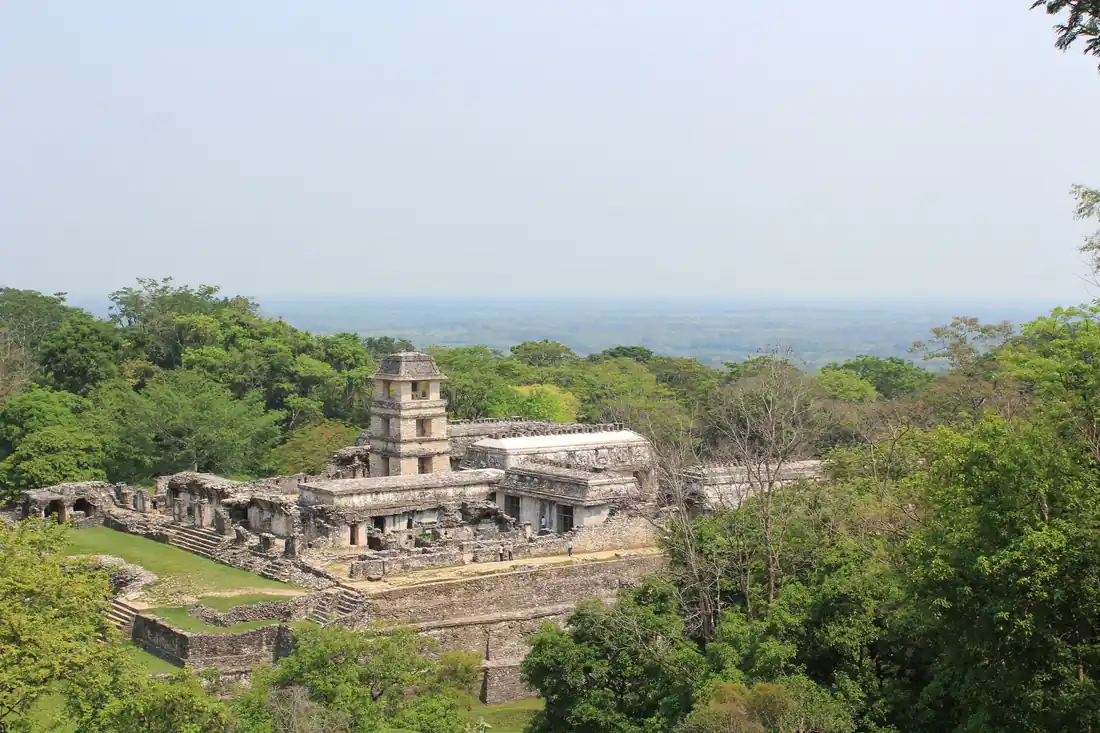
A channel beside the Palace leads to a larger question: how can making room for water also make room for a city? Follow an open stretch, distinguish two waterways and move from a photograph to a survey and a hydraulic interpretation.
Find an open space as well as a building in the Palace photograph. Ask what lies between them.
Separate the visible channel, the covered Otulum section and the different Piedras Bolas conduit.
A similar roof does not establish a similar use. Name the evidence needed to go further.
READING 01
Imagine standing in a plaza. Steps rise towards doorways; a tower draws your eye upward. But looking higher is only half the work. Somewhere below the surface, water may be passing through a stone-covered route. Palenque invites a different opening question: when a stream crosses the place where people want to gather, how do you give both the water and the gathering room?
The ancient Maya centre lies in Chiapas, Mexico. Its monumental buildings offer a compelling first view, but they need not be the boundary of our attention. UNESCO places Palenque within the Classic Maya world. Start with the Palace photograph: pick out a wall, then an opening between buildings, then a change in ground level. These are invitations to investigate, not a reconstruction of a particular ancient afternoon. [1]
INAH explains the ancient name Lakamha’ as the place of great waters. Its account also describes farming, fishing and crafts around the city. People appear alongside the monuments: growing food, making things and exchanging goods. Water belongs within that inhabited landscape, rather than serving merely as a picturesque edge around a royal building. [8]
The Palace itself is a complex rather than a single room. In INAH’s guide, its spaces combine administrative and residential purposes across different levels. Read the photograph from ground to roof as well as roof to ground. Where does a platform end? What route could connect the space beside it with another part of the settlement? The next photograph takes our gaze down to that boundary. [2]
READING 02
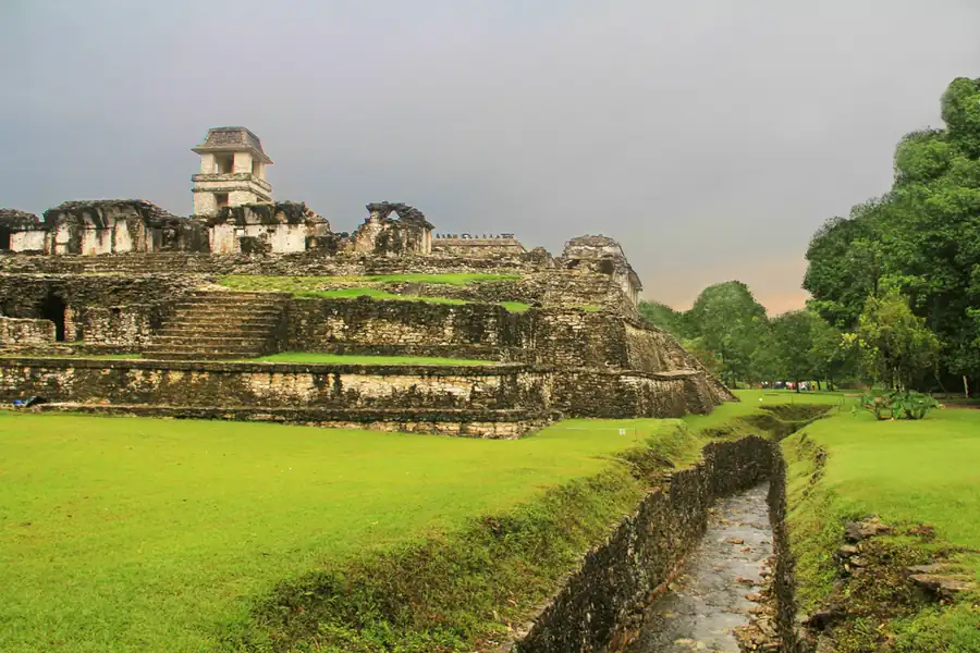
Two stone edges hold a narrow line of water in the second photograph. The image record calls the subject the Palace Aqueduct. What the camera shows here is open to the sky. It does not put us inside a roofed tunnel, and it cannot show the full course beyond its frame. Follow the water with your eye until the photograph no longer answers the question.
INAH traces the aqueduct from mountain springs past the Temple of the Inscriptions, the Palace and the ball court. That description turns an isolated feature into a route among places. Water and human movement occupy neighbouring parts of the city; the task is to arrange their passage through the same limited terrain. [2]
Kirk French’s field report distinguishes a walled channel from a covered aqueduct on the Otulum. It records a surviving OT-A1 stretch carrying the stream 58.5 metres beneath the plaza floor. The number gives a sense of the space hidden below the surface. It is a survey record, not a measurement taken from our modern photograph. [3]
Penn State’s research account describes routing streams below plazas as a way of creating usable urban land and helping manage flooding. Read the covered route in that light. A structure can carry water while allowing another activity above it. The empty-looking area in a photograph begins to acquire depth: the city is arranging not only where things stand, but what can pass underneath. [5]
READING 03
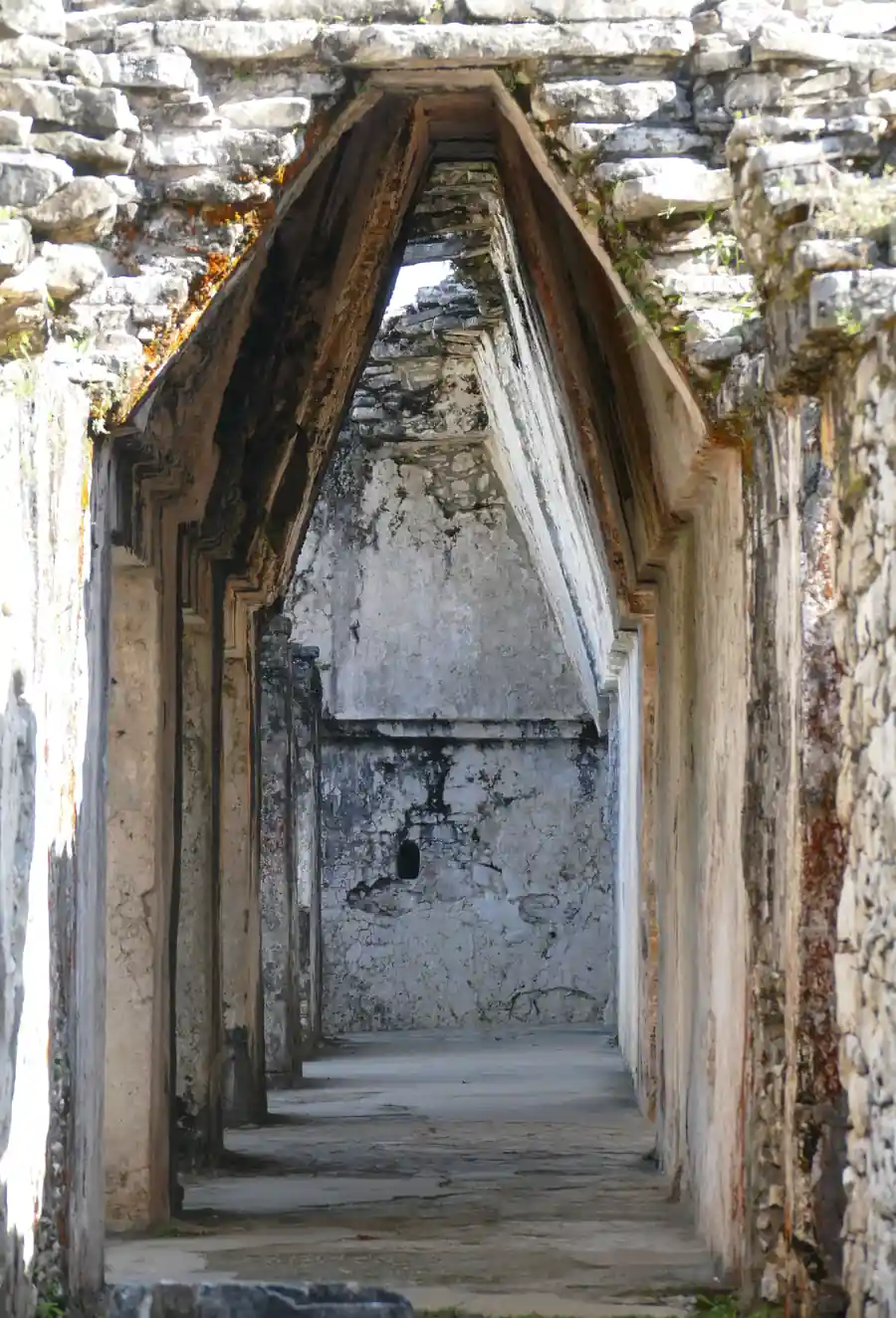
Now look into the third image. The walls approach one another towards the roof, leaving a narrow, sheltered passage. Its record identifies a passage within the Palace. This photograph concerns a space for people; it is not an image of a water conduit. Similar-looking stonework can pose an excellent question, but it cannot supply the answer by itself.
Let the shape become a prompt rather than a label. Ask what passed through an opening, what surfaces contained it and what evidence identifies its purpose. A roof can change how a space is used. Yet a view of that roof alone does not tell us whether the space belonged to movement, storage, drainage or another activity. Return to the building record before giving it a function. [2]
A different inquiry concerns Piedras Bolas. French and Christopher Duffy’s 2010 paper examines pressure in a closed conduit; its abstract reports a potential hydraulic head of up to six metres. This is a conditional result about what the arrangement could achieve. It is not an observed fountain height in the Palace photograph. [4]
Penn State identifies Piedras Bolas as the feature recorded in 1999 and investigated again in 2006. Its research explanation proposes a fountain or lifting water towards neighbouring residences as possible uses. Keep that feature separate from the Otulum beside the Palace. The distinction lets the engineering remain impressive without pretending that every final use has been demonstrated. One city can contain more than one solution to moving water. [5]
READING 04
A monumental centre can dominate a visitor’s mental map. The Palenque Mapping Project of 1998–2000 widened the investigation into the surrounding settlement. Its account describes recording building corners, stream edges and changes in terrain together. Read those categories as a method: a river line and a platform are parts of the same question about how a place was occupied. [7]
French’s survey likewise gives different names to aqueducts, bridges, drains, walled channels, pools and dams. Those distinctions make work visible. Carrying water, crossing it and holding it back are related tasks, but they are not interchangeable. A label should preserve the job being investigated rather than collapse every opening into one generic ancient water system. [3]
A 2012 study by French, Duffy and Gopal Bhatt brings the local watershed into an assessment of climate, land use and ecological conditions. Its abstract argues against explaining departure from Palenque through water deficiency. This is a site-specific research argument, not a reason to give every Maya centre the same environmental history. Regional climate must be considered alongside the conditions of the place being studied. [6]
Return once more to the Palace photograph. After the tower, look at the ground. Hold three images apart: the open watercourse, the route beneath a plaza and the passage in which people could walk. Their relationship is more interesting than a single spectacular label. Palenque’s achievement lies partly in making room for different movements within one urban landscape. Reading it carefully means allowing each route its own identity.
Keep the identity of the waterway attached to each claim. This original guide is not a measured plan or hydraulic simulation.
Visible: An open watercourse beside the Palace platform.
Interpreted: The photograph identifies a visible stretch; it does not measure a different conduit.
Source 3 ↗Visible: A published abstract discusses hydraulic potential at Piedras Bolas.
Interpreted: A conditional head of up to six metres is not proof of an operating fountain.
Source 4 ↗Visible: The institutional research account offers possible uses.
Interpreted: A fountain and lifting water towards residences remain proposals in this account.
Source 5 ↗Choose a wall, an open area and a change in level. The building guide helps relate the complex to the ground; your photograph does not show every underground route. [2]
Describe the open part first. Use the survey to discuss the covered Otulum route; do not claim to see its interior in this frame. [3]
This is a Palace passage for people, not a water-channel photograph. Similar form prompts a question about use; it does not settle it.
Otulum and Piedras Bolas are distinct research subjects. Preserve the place attached to each claim before comparing them. [3], [5]
The abstract gives a potential hydraulic head under the proposed conditions. Keep calculation separate from the final use. [4]
The project records stream edges and terrain changes alongside building corners. Compare those categories with what a single photograph leaves out. [7]
The Palace passage photograph does not establish that function. Its shape alone cannot identify a conduit.
The institutional account proposes a fountain as a possible application of pressure; it does not demonstrate the complete final arrangement. [5]
The 2012 abstract argues from Palenque’s local watershed. Its conclusion should not be transferred unchanged to every other settlement. [6]
INAH’s guide gives this as a period of major growth; other source summaries frame the city’s high point differently. [2]
Palenque enters the World Heritage List. [1]
Palenque Mapping Project surveys the wider settlement. [7]
Piedras Bolas is recorded, then re-examined: research dates, not construction dates. [5]
FAMSI presents the mapping and water-management reports. [7]
French and Duffy’s pressure study is published. [4]
The hydroarchaeological study is published. [6]
No verified Geçmişin Haritası Palenque Reel or master is available. Continue through the institutional site and research records below. No film has been copied, embedded or playback-tested.
UNESCO site record ↗A photograph, field observation and calculation do not become a single structure merely because all concern the same city. Test the links between your statements in the free evidence notebook.
Open the water evidence notebook ↗Original free exercises; no paid Turkish PDF translated or released.
Official overview and inscription record read. Brief source summaries differ on the high-point interval; no exact founding date asserted.
History and aqueduct sections read directly; building uses and landscape context. No current ticket or access advice reproduced.
Selected introduction, definitions and Otulum passages read in the 44-page PDF, including printed pages 17–18 on OT-C1/OT-A1 and 58.5 metres. Not all pages or maps reviewed.
Institutional abstract and metadata read directly: Journal of Archaeological Science 37(5),1027–1032, May2010, DOI10.1016/j.jas.2009.12.003. Full six-page paper not read.
Direct institutional account, last updated8February2011: research dates, urban space and possible uses. No complete final fountain arrangement established.
Institutional abstract and metadata read directly: Latin American Antiquity23(1),29–50, March2012, DOI10.7183/1045-6635.23.1.29. Full paper/model data not inspected.
Presentation introduction and methods summary read: building corners, stream edges and topography. Full map suite not downloaded or reproduced.
Official written account read directly: ancient name, farming, fishing and crafts. Linked audio not played.
Original narrative and English edition: Geçmişin Haritası. Sources checked 29 October 2026. Photograph dates are 2013, 2012 and 2020, not current visitor-condition evidence. Image licences and earlier transformations appear with each image; existing derivatives are unchanged.