Building
Begin with a wall and an opening. Describe their relationship before assigning a room its purpose.
 GEÇMİŞİN
CHACO / NEW MEXICO
From Pueblo Bonito’s rooms to road traces beyond the canyon: read a great house through the relationships around it.
4 readings · 1 public-domain photograph · 5 source records
Read beyond the walls ↓ · Free discovery card ↗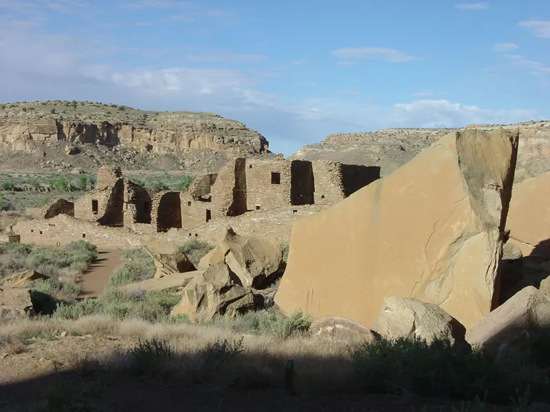
Follow a room boundary, question a road alignment and compare the timescales of a building and a region. Chaco invites us to look beyond the edges of its most familiar photograph.
Begin with a wall and an opening. Describe their relationship before assigning a room its purpose.
Keep a recorded segment separate from a line imagined across a gap.
Read the landscape alongside the continuing relationships of living communities.
READING 01
At the foot of a wall, we usually ask how high it rises. In this view of Pueblo Bonito, another question opens: what kind of gathering could these many rooms and spaces accommodate? Follow the stone lines across the photograph. Notice where one enclosure gives way to another and where a person might pass through an opening. Even without naming every room, we can begin to feel the scale of an arrangement made for people.
The National Park Service places Pueblo Bonito’s planning and construction in stages between 850 and 1150 CE. This is therefore not a photograph of a design completed on a single day. The USGS image record locates the viewpoint on a trail along the cliff between Chetro Ketl and Pueblo Bonito. Knowing where the camera stood helps us distinguish this building from the canyon as a whole. [4], [5]
Let your eye reach the photograph’s edges. Beyond them lie questions the image cannot answer. We cannot count every settlement or identify everyone who once entered these rooms. But a photograph can be a doorway into research. Instead of asking the wall to explain everything, ask which source might carry the story beyond it. The frame becomes a starting point rather than the boundary of the place.
READING 02
UNESCO treats Chaco Culture as a network of sites in northwestern New Mexico. Its World Heritage property includes Chaco Culture National Historical Park, Aztec Ruins and other protected areas. A single great house cannot stand in for that entire geography. [1] Imagine placing one outline around the building and another around its relationships. These are different ways of describing a place, and each directs attention towards different questions.
The NPS describes great houses as planned, multi-storey buildings and identifies Chaco as a ceremonial, administrative and economic centre by 1050. It presents periodic public use as a possible interpretation rather than treating these buildings as ordinary farming villages filled with a large permanent population. [2]
The name “great house” can make us picture a very large household. Pause before accepting that image. A building’s size and a census of its inhabitants are different kinds of information. Think instead about what would be needed to distinguish a meeting place from a residence: evidence of use, its context and its date. Room boundaries make that investigation possible; they do not complete it on their own.
READING 03
We are accustomed to expecting a route to bend around an obstacle. The NPS account of Chacoan roads describes alignments that can continue towards a cliff and climb it using steps or ramps. A line that holds its direction raises a question beyond distance: why was that direction important? [3] This is an invitation to investigate the landscape, not a reason to draw a straight line wherever we would like a connection.
The same account distinguishes a few well-documented long roads from discontinuous segments. Researchers debate whether missing stretches once joined some of them and how symbolic and practical functions related. Walking or carrying goods could benefit from a prepared surface even where a road had ceremonial importance. [3]
Keep the gap visible in your own reading. A solid line, a broken line and an unanswered question should not quietly become interchangeable marks. Our comparison below is a guide to evidence, not a reconstruction of the road network. The rewarding question is not which single explanation settles every road. It is what has actually been recorded along the particular segment under discussion.
READING 04
Changing the timescale changes the view. UNESCO’s synthesis identifies about 1020–1110 as a high point of Chacoan society; its short description uses 850–1250 for the broader regional centre. These ranges do not replace one another. Nor should either automatically become the construction dates of Pueblo Bonito. [1] A timeline is most useful when the reader knows what each date describes.
The NPS describes slower construction and a changing regional role in the 1100s and 1200s, alongside migration and the reorganisation of communities. It also recognises Chaco’s continuing spiritual importance to living peoples and their migration traditions. Change at a centre is not evidence that a people disappeared. [2]
Return once more to the photograph. The stone compartments can now open towards several kinds of enquiry: the history of construction, the recording of roads and relationships that continue beyond the period of monumental building. We do not need to invent a conversation in a room to make the place human. We can ask whose knowledge belongs in the account, and resist letting an impressive ruin become the whole story.
Compare kinds of evidence. This guide is not a map or reconstruction of the Chacoan road network.
In the photograph: Walls and open spaces appear in the photograph.
Reading with sources: A room boundary is observable; its ancient occupancy requires other evidence.
Source 4 ↗In the photograph: This photograph does not show the regional road network.
Reading with sources: Distinguish documented alignments from gaps and proposed connections.
Source 3 ↗In the photograph: A single view cannot date the entire region.
Reading with sources: Pueblo Bonito’s construction range and the regional high point concern different subjects.
Source 1 ↗Describe a wall and an opening. The photograph alone does not establish what every room was used for.
The image record identifies a viewpoint, not a complete survey of the canyon. [5]
No. Use the road account to distinguish recorded stretches from discontinuous segments. [3]
NPS gives 850–1150 CE for phased planning and construction at Pueblo Bonito. [4]
6 July 2005 is the USGS page date. A verified exposure date is not provided here. [5]
A visible enclosure does not identify a permanent population or every activity within it.
Room count is not a direct population count; the institutional account discusses possible periodic public use. [2]
Discontinuous traces should not be silently joined into a confirmed network. [3]
A changing centre and the continuing connections of living peoples must be considered together. [2]
Phased planning and construction of Pueblo Bonito in the NPS account. [4]
High point of Chacoan society in UNESCO’s synthesis. [1]
Regional ceremonial, administrative and economic centre in the NPS account. [2]
Construction slows and the role of the centre changes. [2]
Chaco Culture is inscribed on the World Heritage List. [1]
No verified Geçmişin Haritası Chaco Reel or master is available. Continue through the institutional site and research records below. No film has been copied, embedded or playback-tested.
UNESCO site record ↗Original free exercises; no paid Turkish PDF translated or released.
Direct institutional description and synthesis: regional property, different timescales and 1987 inscription.
Direct institutional text: planning, possible periodic public use, regional change and continuing relationships. Interpretation remains qualified.
Direct institutional text: alignments, steps, discontinuous traces and debated functions. No present trail or access advice reproduced.
Direct place record: phased planning and construction between850and1150CE. Current visitor directions not used.
Direct image record: viewpoint and public-domain rights.6July2005is a page date,not verified capture date. Older abandonment wording not substituted for the distinct building/regional timelines.
Original narrative and English edition: Geçmişin Haritası. Sources checked 29 October 2026. The USGS page is dated 6 July 2005; the photograph’s exposure date is unverified. It does not establish current visitor conditions. The public-domain source and earlier processing appear with the photograph. Source access is described individually.