Plaza
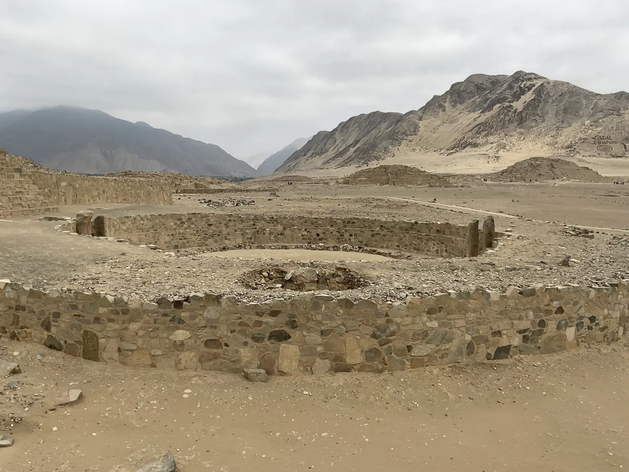
Follow the circle, its entrance and the adjoining platform. Which relationships can you describe before naming a ceremony?
 GEÇMİŞİN
CARAL / PERU
A circle below ground, a platform above it. Follow the connections between space, fibre, stone and a distant coast.
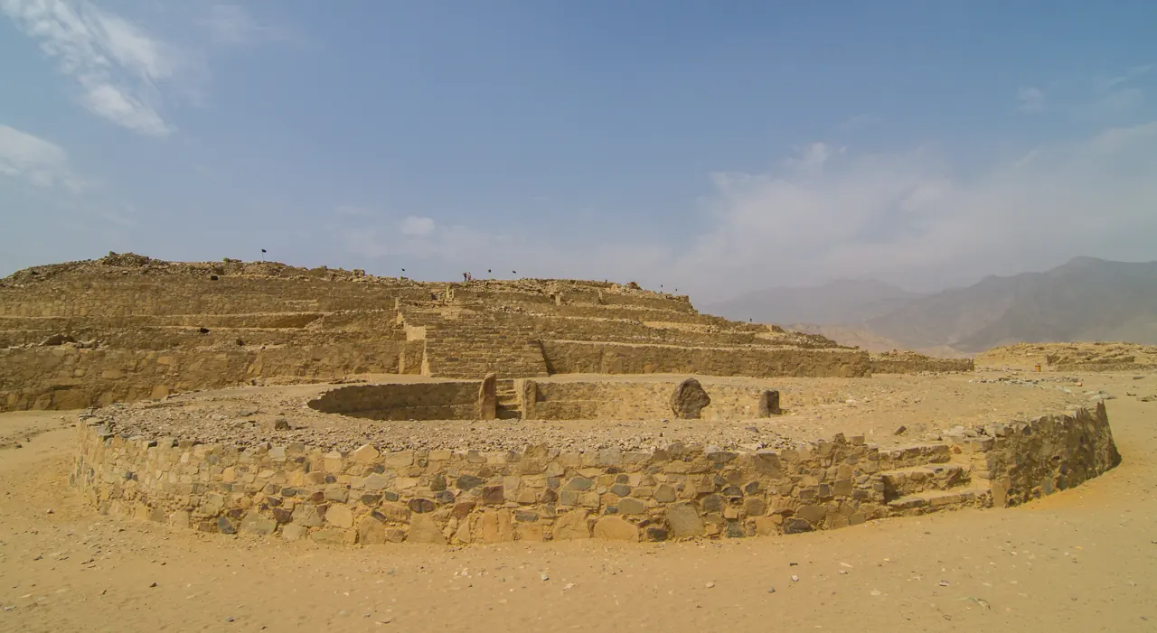
Explore Caral through sunken courts, stone-filled fibre bags and the cotton used in fishing nets. Read the city's building phases alongside the different kinds of dates used to investigate its past.
Choose a scale, then write one observation and one question.
Follow the circle, its entrance and the adjoining platform. Which relationships can you describe before naming a ceremony?
Find the fibres in the close photograph. Match the material observation with ZAC's account of stone-filled shicras.
Trace cotton towards the coast and marine products towards the valley. Which source supports the connection?
READING 01
From a distance, Caral first catches the eye with its rising masses: terraces, walls and steps. To begin reading the city, lower your gaze. The open spaces before the platforms matter too. In this desert settlement overlooking the Supe Valley, sunken circular courts offered an architectural way of bringing people together before a building. UNESCO connects the ceremonial interpretation of the city with its plan and architectural components.[1]
Follow the edge of a circle. Look at the relationship between the boundary, the floor and the entrance. As the building rises, its court descends: the eye follows two movements at once. That meeting offers a richer reading than measuring the monument only by height. A photograph cannot recover the sound of a ceremony or the words of its participants. It can help us ask where people might stand, which way they might enter and what structure they would face.
Caral is not a solitary, mysterious pyramid. UNESCO places it within a wider group of settlements in the region. Monumental platforms and residential spaces belong in the same enquiry. Begin by asking how places connect, rather than which building is tallest. The city's story continues through the spaces between its solid masses.[1]
Nor were these relationships completed in one building campaign. Shady, Machacuay and Aramburú's study of the Templo Mayor, included in the 2003 volume, places the circular plaza after phases of use and remodelling of the pyramidal structure. Components that appear connected today need not have begun together. A city plan can preserve changing needs as well as an earlier arrangement.[6]
READING 02
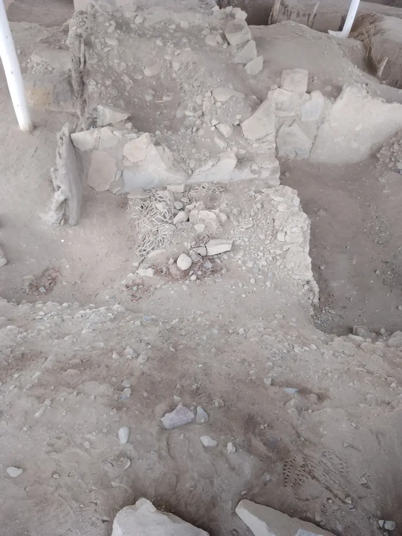
Approaching a stone surface changes the scale. What looked like a single mass becomes individual pieces put in place. The visible wall is one face of completed work; its fill carries another kind of information. Zona Arqueológica Caral describes shicras: woven plant-fibre bags filled with stones and used in platform and foundation fills. Fibre joins stone in the architectural story.[3]
Gathering stones and weaving a bag require different skills. Their meeting within a structure suggests a sequence of connected tasks: preparing, carrying and placing material, then organising the growth of a platform. Try distinguishing the pale fibres from the stones in the close photograph. Read the image beside the excavation explanation to consider how a fine material could participate in a heavy structure.
ZAC's article of 7 August 2026 also discusses research on the earthquake behaviour of these fills, considering the bags together with stepped walls. This invites us to see accumulated knowledge of materials and construction alongside the appearance of a ruin. Studying an ancient technique does not guarantee that every building would remain undamaged in every earthquake. The discovery here is an enquiry into the work within the stone, rather than a ready-made modern building specification.[3]
READING 03
A fishing net may seem an unexpected companion to the desert's stone colours. Yet a city's life depends on more than the resources visible inside one photograph. ZAC's account of cotton links fibre production in the valley with coastal fishing. Cotton supplied material for nets; marine products formed part of exchange networks. A cultivated field could therefore provide the means for another kind of production, as well as food.[4]
Read the connection in both directions. While imagining a product travelling from coast to valley, remember the material moving towards the coast. A net requires fibre, skilled work and knowledge of fishing. Behind the life gathered around a plaza were people working elsewhere who needed one another. This is not a trade map extracted from a landscape photograph alone. It is a way of looking widened by archaeological research.
The institutional article, published in 2016, also discusses native coloured cotton, including brown shades, and a contemporary production and craft initiative. Keep these times distinct. A present-day weaving activity cannot be a photograph of an ancient event, but it can renew a question about why a material mattered. Returning to Caral, we can look for fibre alongside stone, and for a distant coastline beyond the plaza.[4]
READING 04
A wall's age cannot be measured by how weathered it looks in a photograph. Dating needs other evidence. The abstract of Ruth Shady Solís, Jonathan Haas and Winifred Creamer's Science paper, published on 27 April 2001, reports calibrated radiocarbon dates spanning 2627–1977 BCE. These measurements help place investigated remains in time; they do not say that every structure in the city was founded on the same day.[5]
Keep that reported range beside the broader development period of about 3000–1800 BCE used by UNESCO and the site authority. A dated sample and a settlement's long history answer questions at different scales. That is why the chronology gives them separate entries. Instead of treating an oldest-city label as the result of a competition, ask which date comes from which evidence.[1][2]
Caral entered the World Heritage List in 2009. This marks recognition of its heritage, not the beginning of ancient settlement.[1] Return to the wide view. The height of a platform, the outline of a circular court and knowledge of the fill are now connected details. Together they invite us to consider how space, materials and human relationships build a city. Do we read shared life only through what people raised above the ground, or also through the connections they made between one another?
The Templo Mayor study places the circular plaza after use and remodelling phases of the pyramidal structure. Their present connection does not prove a simultaneous beginning.[6]
Shicras are woven plant-fibre bags filled with stones. Look for the material in the photograph, then investigate its use through the institutional explanation.[3]
Sample dates, architectural phases and a settlement's broad development period operate at different scales.[5]
The Templo Mayor study places the circular plaza in a later phase. A photograph alone cannot establish that sequence.[6]
Research into an ancient fill technique is not a promise of no damage in every earthquake or evidence of compliance with modern building codes.[3]
Broad development period presented by UNESCO and the site authority.[1][2]
Dates reported in the 2001 abstract; not the beginning and end of every structure.[5]
Publication of the Science paper by Shady Solís, Haas and Creamer.[5]
Publication of the archaeological volume containing the Templo Mayor plaza study.[6]
World Heritage inscription.[1]
ZAC's article on coloured cotton and contemporary production work.[4]
ZAC's explanation of shicras and research on structural behaviour.[3]
No verified Geçmişin Haritası Caral Reel or master film accompanies this story. Visit the official UNESCO / NHK video page ↗. Its film remains with the rights holder; it has not been copied or embedded here.
Explore Museo Caral Virtual ↗ and explore its thematic rooms and learning activities.
Describe the plaza, investigate fibre and stone, trace a coastal connection and distinguish the scope of different dates.
Open the free Caral discovery card ↗Original free English worksheet; not a translation or release of a paid Turkish PDF.
Ceremonial architecture, broad development period and2009 heritage inscription; earlier conservation assessments are not present conditions.
Site-authority overview; different property/core areas are not merged and promotional peace language is not historical proof.
Institutional account of stone-filled fibre bags; not a full engineering test report or an earthquake-proof guarantee.
Cotton, fishing nets and marine-product exchange; the 2016 production initiative is separate from antiquity.
PubMed abstract and metadata only, not the full Science paper. Calibrated 2627–1977 BCE sample range is not one founding date; BP is not calendar BCE.
Targeted TemploMayor plaza sequence in the 2003 volume, printed p.159; not a claim to have read the entire volume. No book illustrations copied.
Thematic rooms, object focus and educational workshops; external immersive controls/360 tours not tested.
Official source link only; no film copied or embedded, no external playback/audio/subtitle test.
Original narrative: Geçmişin Haritası. English edition: 26 October 2026. Institutional records, the 2001 abstract and targeted 2003 excavation sections checked. Photographs dated 2016 and 2022 do not establish present visitor conditions. The shicra image credit follows the existing verified 23 October 2026 production record; its Commons page was unavailable during this check. No institutional partnership or endorsement is claimed.