Observation
A pale line on a red painted surface.
 GEÇMİŞİN
MEXICO / TEOTIHUACAN
From a monumental avenue to a courtyard, from a courtyard to a painted wall. Read a city at three different scales.
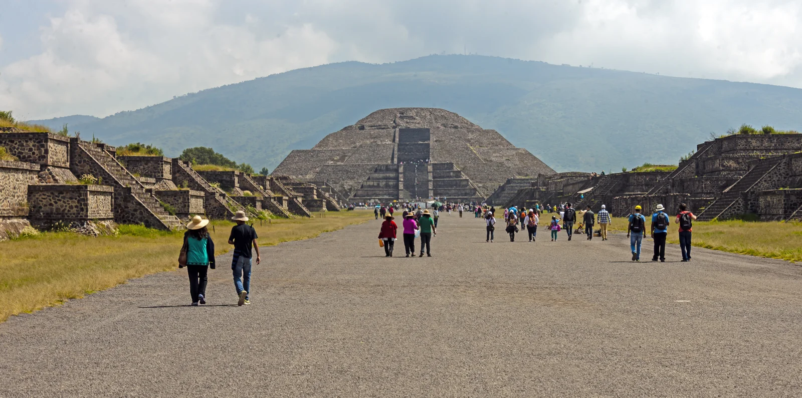
An avenue, courtyard homes and colourful walls bring us closer to the lives within Teotihuacan’s commanding lines.
Change scale. Choose a detail in the photograph before reading what a source adds.
Look: Trace the edges of the avenue. Which homes does this view leave outside the frame?
Read with sources: The urban setting includes residential spaces as well as the ceremonial axis. [1]
Return to the photograph ↓Look: Pause at an opening in Tetitla. Ask about passage, light and the adjoining room.
Read with sources: INAH explains courtyard functions; UNAM compares different arrangements of rooms and open space. [3],[5]
Return to the photograph ↓Look: Name a colour and a line without naming the figure.
Read with sources: The Met leaves more than one possibility for its separate Techinantitla mural. Keep the two objects distinct. [6]
Return to the photograph ↓A pale line on a red painted surface.
A proposed identity or meaning for the figure.
Which object record and supporting evidence could test that proposal?
This original reading guide uses the distinction between visual description and a museum interpretation. It does not identify the Tetitla figure from the separate Techinantitla record. Compare source 6 ↓
READING 01
The Moon Pyramid gathers our gaze at the far end of the photograph. Stepped platforms frame the avenue on either side, while the mountain behind seems to continue the outline of the stone. The people walking towards it are modern visitors. Removing them in our imagination would not restore an ancient view. It would simply open another question: in the city surrounding this great space, where did a day begin, and where did it end? Let the distant pyramid hold that question while your eyes move towards the edges of the road.
UNESCO reads the city’s monuments, layout and natural setting together. Even the San Juan River was redirected to cross its principal avenue. Building here involved arranging water, terrain and structures in relation to one another, as well as laying stone upon stone. The landscape belongs inside the story of construction; it is not merely a backdrop waiting behind the buildings. [1]
The Met’s 2024 essay leaves a useful question open: did the orderly monumental layout follow a single master plan, or emerge through shared principles over time? A powerful line in a photograph shows us an arrangement. It cannot reveal every decision, decision-maker or moment that produced it. For now, leave the largest structure at the end of the road and look for the city’s smaller openings. [2]
READING 02
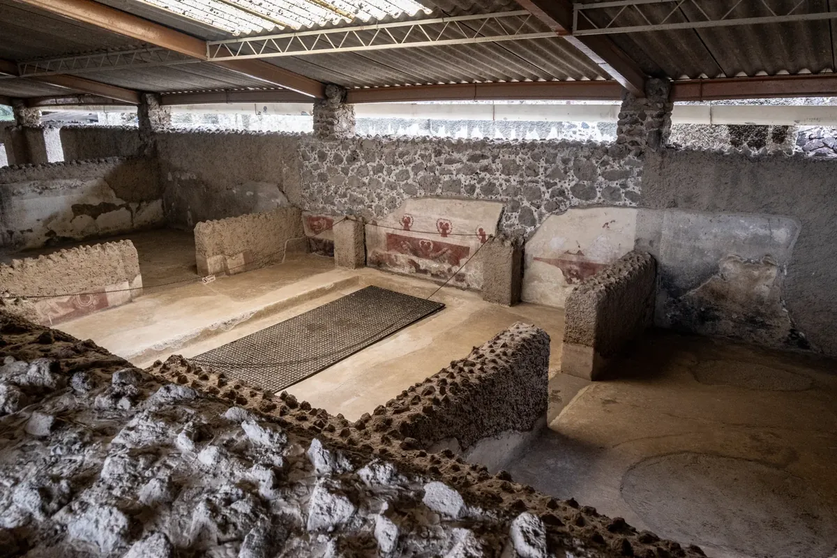
At Tetitla our field of view contracts. Low walls, openings, steps and painted surfaces overlap. The metal supports and corrugated covering overhead belong to the protective structure visible in the photograph; we are not looking directly at the roof of an ancient home. Beneath it, follow the boundaries of the rooms. Where does an opening narrow? In which direction does a wall continue? The foreground stonework interrupts our view, reminding us that seeing part of a building is different from knowing the whole of its plan.
INAH describes residential rooms grouped around courtyards that admitted light and air and helped collect rainwater. Its account brings rest, food preparation, storage, work and worship into the same domestic setting. These uses encourage us to read a home as a relationship between activities, rather than a set of sealed boxes. A room’s position matters alongside whatever happened inside it. [3]
UNAM’s Tetitla presentation compares two arrangements labelled A and B: a larger courtyard with fewer rooms, and a smaller open area with more rooms. The changing balance of open and enclosed space gives us something precise to compare. Instead of imagining every home as a copy, ask what different habits two courtyards might accommodate. That is our proposed reading question, not a recovered diary of a particular household. [5]
READING 03
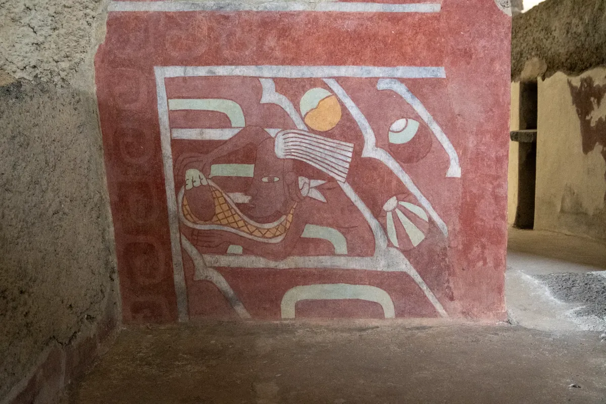
The third photograph brings us close to a red wall. Pale lines enclose a figure; yellow and greenish areas stand out between worn patches. Around the painted surface, plaster and stone have different textures. A wall that divided spaces now holds an image asking for our attention. Keep both functions in mind: making a room, and shaping what could be seen within it. Before giving the figure a name, choose a line that your eye can follow from one end to the other.
Archaeologist Elba Estrada Hernández’s account for the Museo Nacional de Antropología approaches residential paintings as evidence of Teotihuacan’s colourful appearance and shared visual expression. It also presents changing interpretations of particular scenes. Social and religious readings require investigation; a mural cannot simply stand in for a photograph of an event. Colour, repetition, position and relationships with other finds become questions to pursue together. [4]
A particular museum object sharpens that distinction. The Met’s mural 2012.517.1 comes from Techinantitla and is dated 500–550 CE. Its central form may be a deity or an undeciphered complex logogram. This is a different work from the Tetitla photograph on this page. Compare the records without merging the figures. A similar red does not, by itself, give two images one certain meaning. [6]
READING 04
Even the avenue’s familiar name carries a later reading. INAH connects the Avenue of the Dead with the Mexica, who understood the raised structures beside it as tombs. Knowing a place-name does not necessarily identify its original function. Naming a place and understanding the people who lived there are separate steps in an investigation. The name can be part of the history we study, rather than a ready-made answer to every question about the road. [3]
The city’s transformation also resists a single closing scene. The Met distinguishes fires in the monumental core around 550 CE from a marked population decline after 600. UNESCO describes legends gathering around the ruins in later centuries. Physical change and new meanings in other people’s memories can belong to the same place, without happening at the same time. [1],[2]
The three photographs propose a route through scales: notice the whole, approach the spaces, then pause at a surface. While looking down the avenue, do not forget the rooms. While examining a room, do not hurry to close the meaning of its painting. The city’s fascination lies in more than the size of its pyramids. There are still many doors through which to ask about the lives around them. Each change of scale offers another way to begin.
Start the discovery card with one line from the avenue, one opening from Tetitla and one colour from the mural. Beside each, write what you can actually observe before adding what a source tells you. Return to the photograph after reading. Does the information answer your question, or make it more exact? Instead of leaving Teotihuacan behind as a single immense panorama, carry it with you as three connected questions.
Find a strong line in the first photograph, then write one question about everyday life that the view leaves unanswered. INAH’s residential account supplies a different scale of evidence. [3]
Locate the metal structure above Tetitla. Distinguish this modern protective covering from the low walls below it. Trace a wall and an opening before imagining a complete ancient roof.
Describe one colour and one line without identifying the figure. Compare your description with the possibilities in the separate Techinantitla object record. Observation and interpretation do different work. [6]
INAH associates the name with a later Mexica interpretation of the raised structures as tombs. The familiar name is not direct proof of their original use. [3]
The Met separates fires around 550 CE from population decline after 600. These are distinct changes, not evidence for a single night of total evacuation. [2]
No. Our two close photographs show Tetitla. The Met’s mural 2012.517.1 is from Techinantitla. Keep their locations and records distinct when comparing them. [6]
Period of monumental construction in The Met’s account. [2]
Apartment compounds spread through the city. [2]
Date assigned to the Techinantitla mural, Met 2012.517.1. [6]
Core monuments burned; those responsible remain unidentified. [2]
Marked population decline, distinguished from the fires. [2]
Monument restorations discussed by UNESCO, including intervention at the Sun Pyramid. [1]
Beginning of INAH-coordinated archaeological research as described by UNESCO. [1]
Inscription on the UNESCO World Heritage List. [1]
Construction, changes in population and modern research are different events. These dated photographs do not establish current visitor access or conditions.
No verified Geçmişin Haritası Reel or master film accompanies this story. UNESCO’s official video page ↗ credits TBS and UNESCO/NHK. Those films remain with their rights holders; follow the source to watch. No video has been copied or transferred here.
Explore UNAM’s Tetitla presentation ↗ · Read the Met mural record ↗
Bring the three scales together in your own words, then separate what you saw from what you inferred.
Open the free four-question Teotihuacan discovery card ↗Original free English worksheet; not a translation or release of a paid Turkish PDF.
Original narrative: Geçmişin Haritası. English edition: 26 October 2026. Institutional texts and the three image records were checked for this edition. The MNA account was read through its officially indexed text after direct retrieval failed. Tetitla photographs and Met object 2012.517.1 are separate records. UNAM models and institutional photographs were not copied. External film, audio and subtitle playback have not been verified.