Material
Describe a visible form, then consult the technical record.
 GEÇMİŞİN
AÏT BEN HADDOU / MOROCCO
Step inside a silhouette. Follow a wall’s surface towards shared spaces, building skills and the work of keeping a place alive.
4 chapters · 3 licensed photographs · 8 sources
Approach the first detail ↓ · Free discovery card ↗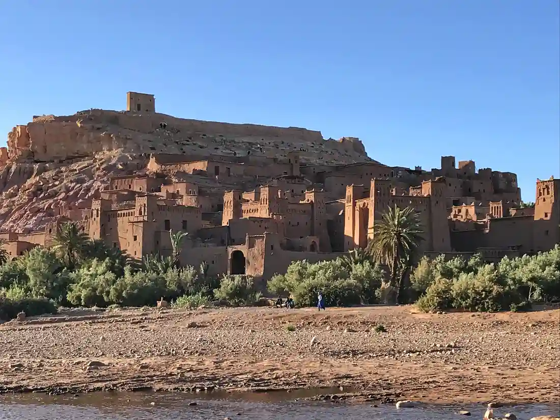
Aït Ben Haddou is a settlement rather than a single palace. Read its clustered houses, patterned walls and open passage through three connected questions: what is it made of, how is it used, and who keeps it going?
Describe a visible form, then consult the technical record.
Ask what connects a house, a passage and a shared space.
Ask whose skills and decisions sustain the place.
Separate houses within the skyline; the ksar is not a single palace.
Compare plain surface and patterned masonry without treating one view as a complete building section.
Follow the path, then ask about continued use and shared care. A photograph cannot identify all users.
CHAPTER 01
From a distance, the houses seem to climb onto one another’s shoulders. Corner towers, broad surfaces and strips of shadow combine into a single shape against the hillside. Begin at the open ground in the foreground of the photograph and let your eye travel upwards. Where one wall ends, another building begins. The first question is hidden within that apparent unity: how many separate lives could this silhouette contain? Looking closely turns a striking outline into a place with different rooms, thresholds and relationships.
Aït Ben Haddou lies in the Ounila Valley, in Morocco’s Ouarzazate province. UNESCO describes a ksar: a group of dwellings and shared spaces enclosed by defensive walls. It is not one enormous palace. Some houses are modest; others have more elaborate forms. Reading the settlement at this smaller scale changes the subject from a solitary grand building to the arrangement of a community. The skyline brings the buildings together without making them identical. [1]
The age of a tradition is another question from the age of a particular wall. UNESCO cautiously places the oldest surviving constructions no earlier than the seventeenth century, while recognising earlier building traditions. Similar colour does not make every surface contemporary. The site also belonged to a trading route linking the region south of the Sahara with Marrakesh. A compact view therefore opens onto a wider world of movement. Its walls invite us to think about connections as well as enclosure. [1]
CHAPTER 02
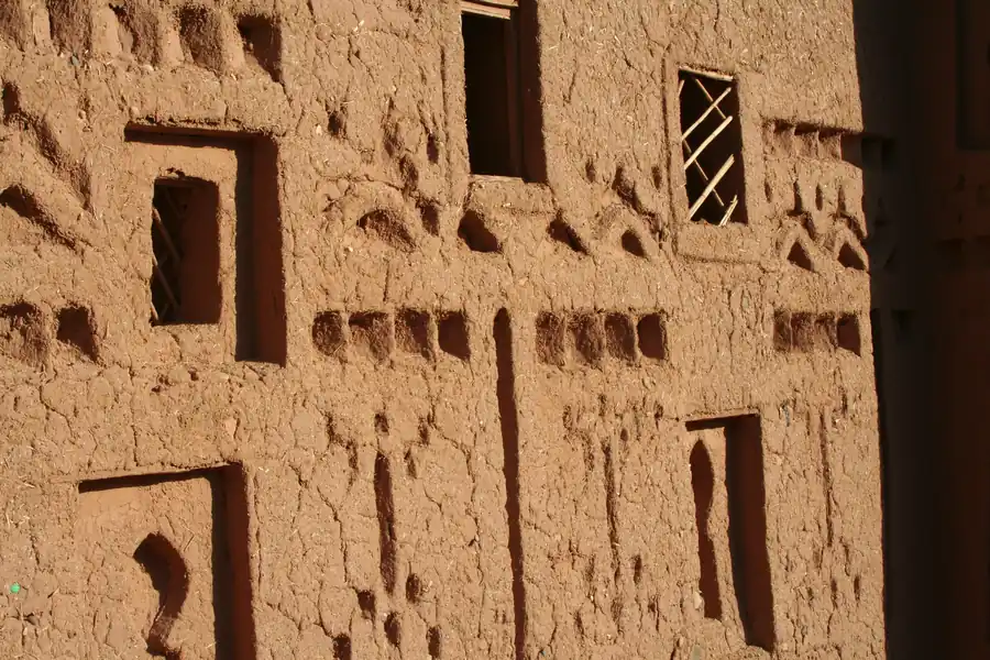
In the second photograph, the wall stops being a distant patch of colour. Light catches edges and recesses; small openings interrupt the surface. Move from a plain area towards the geometric decoration. An element almost lost in the broad view can become the centre of attention at close range. Take time to describe the pattern before deciding how it was constructed. What does the photograph show directly, and what would require a technical record?
Gandreau and Delboy’s earthen-architecture inventory describes predominantly rammed-earth construction at the ksar, with adobe in upper parts and stone foundations. It also identifies adobe masonry in the geometric decoration. Earthen building therefore does not mean one uniform set of identical bricks. The inventory helps distinguish techniques; this single surface photograph does not reveal every layer of the entire building. A material description and a visible pattern can illuminate one another without becoming the same kind of evidence. [2]
Behind those forms are skills: knowing which material belongs in which part, how it is worked and how it can be repaired. The 1999 ICOMOS charter treats the recording and transmission of craft knowledge as part of conservation. Getty’s Earthen Architecture Initiative similarly connects research with practical projects and training. These approaches suggest a further question for our visit through photographs. Beyond admiring a pattern, can we ask what someone needs to know to maintain it? The useful knowledge does not end on the day a wall is first built. [3], [4]
CHAPTER 03
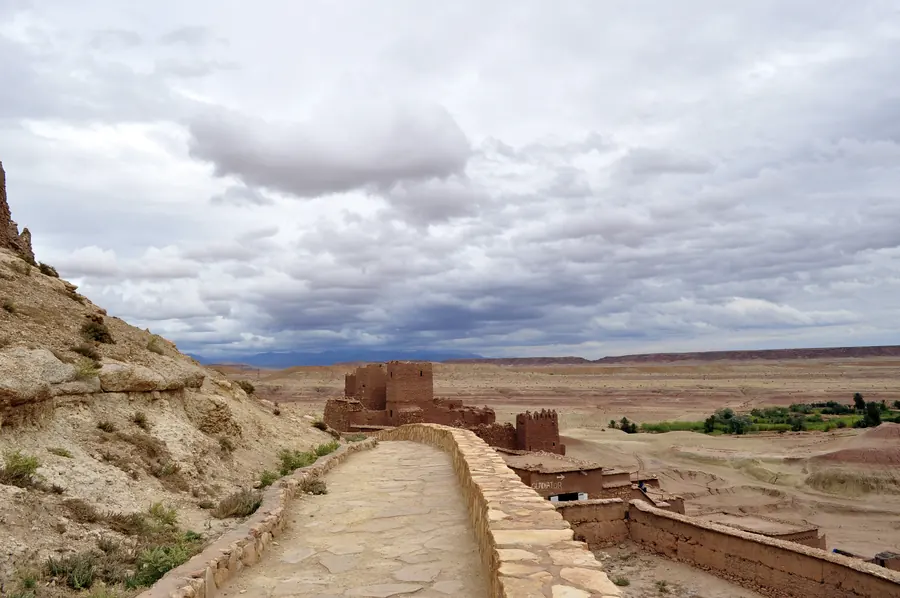
The open passage brings the viewer inside the distant silhouette. Follow the curve of the path between the rising ground and the low wall. Beyond it, the valley opens beneath a broad sky. The photograph connects nearby surfaces with a wider landscape. It does not tell us everyone who used this route, nor does it identify a specific historic procession. Its strength is different: it helps us imagine how a settlement can be experienced through movement rather than seen only as an outline.
UNESCO’s description includes shared places alongside dwellings: a square, a mosque and threshing areas, among others. Home is therefore more than the space behind a closed door. The relationship between a dwelling and a common place matters too. This passage can begin that question without being assigned an undocumented ceremonial function. We can ask where a route leads, what it connects and how its use might depend on neighbouring spaces. [1]
The account of technical assistance in 2008 includes circulation of an Arabic management plan and regular stakeholder meetings. Conservation appears as a process of discussion as well as construction. At the separate site of Taourirt, Getty and CERKAS’s 2011–2016 project connected building fabric, appropriate reuse, participation and training. That project did not take place at Aït Ben Haddou. It offers a comparison in method: preserving a handsome wall can require decisions about the life around it. [5], [6]
CHAPTER 04
Can an old house remain useful without ever changing? Opening its door, maintaining its roof and responding to its occupants’ needs all happen within time. The ICOMOS charter recognises continued use and maintenance, and does not normally seek to make every part conform to a single period. Conservation can therefore begin with understanding successive changes rather than making them disappear. The question is not simply how to freeze a familiar view. It is how to care for a place whose history includes adaptation. [3]
The World Heritage Committee’s 2024 decision addresses assessments and stabilisation following the earthquake of 8 September 2023. It also raises concern about commercial and tourist uses displacing residential functions. The 2026 decision considers coordination of interventions, risk management and visitor flows. These records show an ongoing management process; they are not a certificate that every repair is complete or that all present visiting conditions have been checked. Being attractive to visitors and remaining a place for living are related responsibilities. [7], [8]
Return to the distant view. The spaces between houses no longer look empty: they are part of the settlement’s shared life. A wall’s surface is no longer merely a colour: it carries questions about material, skill and repeated care. Its future cannot be read from a photograph alone. Yet the photograph can start a better conversation. Instead of ending with how old the place is, ask what needs to continue so that the settlement can have another chapter.
Separate the houses and towers in the photograph. UNESCO’s record identifies a collective settlement with community spaces. [1]
Compare plain and patterned areas. The inventory distinguishes materials, but one photograph is not a section through the whole building. [2]
The ksar contains dwellings and shared places. Treating the silhouette as one building conceals that distinction. [1]
A long building tradition does not give every existing wall the same age. UNESCO’s cautious surviving-building chronology is not a verified foundation legend. [1]
The charter values understanding change and continued use; uniformity to one period is not normally the goal. [3]
UNESCO’s cautious dating of the oldest surviving constructions; not the beginning of the building tradition. [1]
Inscription on the World Heritage List. [1]
ICOMOS adopts its Charter on the Built Vernacular Heritage. [3]
CRAterre-ENSAG technical-assistance mission. [5]
Getty/CERKAS conservation-planning project at the separate site of Taourirt. [6]
Publication of the earthen-architecture inventory. [2]
Earthquake subsequently addressed in the Committee’s conservation decisions. [7]
No verified Geçmişin Haritası Reel or master accompanies this edition. Continue with UNESCO’s site record ↗ or Getty’s earthen-architecture research ↗. These are reading links; no video was copied, embedded or verified as playing.
This worksheet is not a translated paid PDF. Existing prices, paid files and product access are unchanged.
Site synthesis, collective dwellings, shared spaces, trade route, cautious seventeenth-century surviving-building chronology and 1987 inscription. Historical2009 management text is not presented as current.
Downloaded PDF; page63/printed62 material paragraph read. Rammed earth, upper adobe, stone foundations and adobe decoration. The page’s1985 inscription date conflicts with UNESCO1987 and is not adopted; full inventory not read.
Three-page charter read: community participation, continued use, care, craft transmission and change over time. General principles, not a specific-house intervention report.
Official project overview read: research, model projects, training and knowledge exchange; linked reports/videos not all reviewed.
Official historical project summary read: June2008 mission, Arabic plan circulation and stakeholder meetings; not a present-day completion record.
Official2011–2016 project overview read: fabric, reuse, participation and training. Taourirt is a separate site; no transfer of its project history to Aït Ben Haddou.
Decision text read: post8September2023 earthquake assessments/stabilisation and balance of residential with commercial/tourist uses. Linked reports not all read.
Decision text read: intervention coordination, management structure, risk and visitor management. Not proof of completion or current visitor safety.
Original writing and English edition: Geçmişin Haritası. Sources and image rights checked 29 October 2026. Modern photograph dates do not date the buildings; no current visitor-access or safety assessment is implied.