Stone
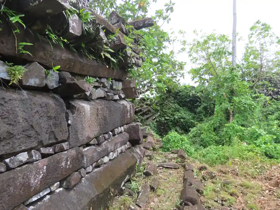
Follow the long sides and outward-facing ends of the blocks. Separate what is visible from the geological source a laboratory can investigate.
 GEÇMİŞİN
NAN MADOL / POHNPEI
From a stone’s source to a piece of coral’s age: explore the work, authority and changing knowledge behind Nan Madol’s channels.
4 readings · 3 licensed photographs · 8 source records
Follow stone, samples and stories ↓ · Free discovery card ↗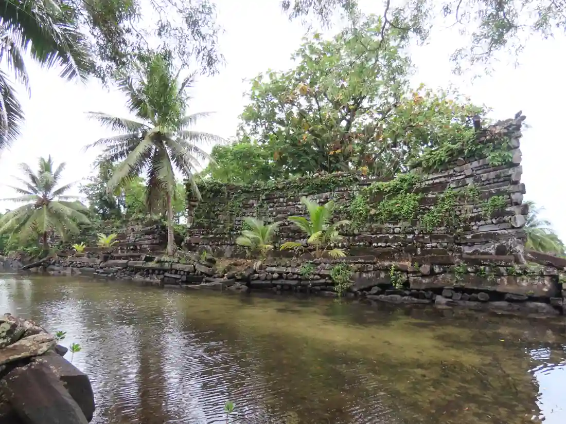
Basalt walls rise beside water on Pohnpei. Follow their materials into geological research, their construction into dating studies, and their continuing significance into Pohnpeian tradition. The strongest discovery may begin with learning which question a particular piece of evidence can answer.
Follow the long sides and outward-facing ends of the blocks. Separate what is visible from the geological source a laboratory can investigate.
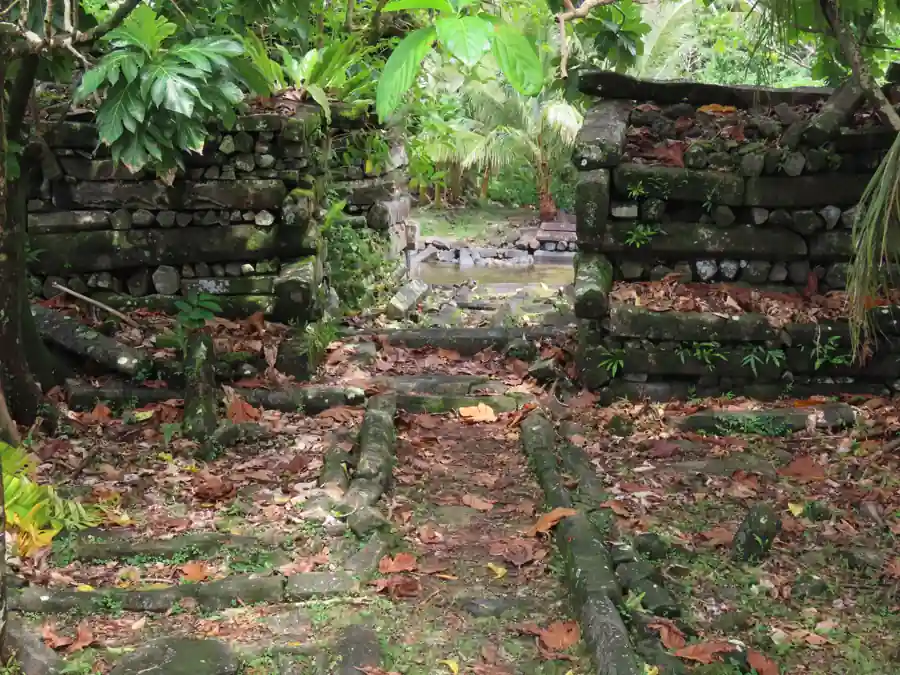
Pause before the steps. Ask what is known about the photograph’s location before giving the opening a name or age.
Read a foundation tradition alongside archaeological research. Then consider what keeping this place means for living relationships.
READING 01
First comes the water. Then you notice the dark stone immediately behind it. The wall’s lower edge approaches the moving surface; roots and leaves enter the masonry above. Weight and movement share a frame. Stay with that contrast for a moment and the question changes: how did these stones reach this place, and whose work sustained such an arrangement?
Nan Madol lies beside Temwen, off the southeastern shore of Pohnpei in the Federated States of Micronesia. Constructed islets, channels and monumental walls form a ceremonial centre. UNESCO identifies residences, ritual structures and burial places associated with Saudeleur authority. Water becomes more than a picturesque foreground: it helps us read how spaces were separated and related. [1]
Do not picture an ordinary modern city containing every kind of neighbourhood. The International Archaeological Research Institute’s account stresses high-status residence, religious activity and burials. Its interpretation directs attention towards a setting with particular social purposes. The question of who could enter a space matters alongside the question of how high its walls stood. [2]
A photograph gives those questions a starting point, not a complete plan. Its waterline records a dated view rather than an unchanging coast. Imagine tracing the boundary with your eye, then deliberately leaving room for what the image cannot show: earlier ground conditions, routes outside the frame and the people whose decisions gave these places their significance.
READING 02
Move your gaze along the second photograph. Some stones show their long sides; others turn an end towards you. Smaller pieces occupy the intervals. What looked like a single dark mass becomes a varied arrangement of parts. Begin by describing those directions. You can notice the wall’s organisation before attempting to reconstruct an entire building operation.
One way to investigate the stone’s earlier journey is to examine its composition. McCoy and Athens’s 2012 study compared architectural basalt with Pohnpei’s volcanic sources using X-ray fluorescence. The sampled columns and boulders did not show the same geological pattern. Material selection and movement emerge behind the masonry, rather than a single undifferentiated pile of rock. [3]
That analysis does not tell us exactly how every block was lifted. It does allow concrete questions about source and selection. Think also of the transport and placement effort emphasised by IARII. A column becomes more than an impressive shape when we imagine the work between its geological setting and its position in a wall. The unknowns are invitations to investigate, not reasons to abandon human craftsmanship as an explanation. [2]
Stones and places make another journey when they enter records. A field survey published in May 2015 paired precise GPS mapping with an annotated concordance of variant islet names. That helps researchers recognise a place across different publications. Our photograph records do not establish an exact islet for the stepped opening, so we leave it unnamed rather than turning it into the entrance of a particular tomb. [4]
READING 03
Imagine standing before the steps in the third photograph. Vegetation is visible beyond the opening. All the stones need not have arrived on the same day. A building’s age may resist being reduced to one label applied to every surface. Asking what a researcher measured can be as interesting as the date that measurement produced.
Research published in 2016 used uranium-thorium dating on coral associated with the central tomb at Nandowas, placing that monumental construction in 1180–1200 CE. This is not a foundation date for every islet. A sample’s position and relationship to a structure turn a large historical question into a narrower one that can be tested. [5]
The 2024 study widened the sequence. Coral ages, considered with excavated charcoal dates, suggested two main construction phases between the early tenth and early fifteenth centuries. The authors also proposed links between environmental change and social dynamics. A broader sequence does not simply erase the earlier tomb date; it gives that result another setting in which to be read. [6]
Keep three steps separate: the sample, its date and the interpretation built from it. A material age and a political explanation are different kinds of statement. The suggested environmental relationship remains a hypothesis, not a single proven cause for the end of a dynasty. Here history becomes more accessible precisely because the path from measurement to argument stays visible. [6]
READING 04
Nan Madol’s walls also belong to stories. In the Pohnpeian oral tradition presented by the National Park Service, the brothers Olisihpa and Olosohpa build with powers received from gods. Read this as a foundation narrative, with its own sense of sacred beginnings. It is not a laboratory measurement of a construction technique, yet it matters for understanding how a place can carry meaning. [7]
Caring for stone and caring for water are connected tasks. UNESCO’s conservation news of 9 November 2018 set out work on vegetation, the channels’ siltation and hydrology, and detailed documentation of individual features. The article describes project aims, not proof of present conditions or completed conservation. The greenery in our cover photograph opens a maintenance question as well as a visual pleasure. [8]
Nor is this only the setting of a vanished political order. UNESCO connects the site with continuing Pohnpeian ceremonial traditions and Nahnmwarki authority. Local relationships belong in a reading of walls, burial spaces and passages. A photograph does not make every opening a public visitor route; respect for meaning begins by noticing the limits of what a view grants us. [1]
Return once more to the first image. Alongside the water we can now think about stone sources, transport work, the research that asks a structure’s age, and relationships that require care. Nan Madol need not hide every answer to remain compelling. Standing before one wall and learning to ask a better question is already a form of discovery.
Ask what each kind of evidence can establish. This original guide is not a measured plan or a reconstruction of an identified tomb.
In the photograph: The photographs show stones and built surfaces, not identified dating specimens.
Reading with sources: Ask whether evidence is coral in construction or charcoal from an excavation, and where it came from.
Source 5 ↗In the photograph: A stepped opening is visible; its exact islet has not been established by its image record.
Reading with sources: Separate the Nandowas tomb result published in 2016 from the wider sequence proposed in 2024.
Source 6 ↗In the photograph: Water and vegetation share the present-day view with masonry.
Reading with sources: A proposed environmental influence is a historical hypothesis, not a political cause read directly from a photo.
Source 6 ↗Compare the wall’s lower edge with the water. Read the channels through the site record, without treating a 2023 photograph as a permanent shoreline measurement. [1]
Long sides, ends and smaller pieces are visible. The XRF study asks a different question about geological source; neither the quarry nor the lifting equipment is shown here. [3]
It compares chemical composition to investigate geological source. That is different from demonstrating the precise transport or lifting method for every stone. [3]
The 2015 survey connects spatial records and variant names. A date or function should remain attached to an identified place rather than migrate to any similar-looking wall. [4]
Its sample and archaeological context. The 2016 coral result relates to the central tomb at Nandowas, not a simultaneous foundation of the whole site. [5]
The NPS presents Olisihpa and Olosohpa within Pohnpeian oral tradition. Their powers belong to that foundation narrative, not to measured evidence of the physical building method. [7]
No. It is associated with coral from a specific tomb context. Other construction belongs within a wider sequence. [5]
The 2024 authors propose an environmental relationship. Dating results do not establish one certain chain of political causes. [6]
Period containing the two main construction phases proposed by the 2024 study. [6]
Coral dating associated with the central Nandowas tomb construction, published in 2016. [5]
IARII investigations directed by J. Stephen Athens. [2]
Publication of McCoy and Athens’s XRF study of architectural basalt. The PDF filename’s 2011 is not its publication year. [3]
Publication of the GPS field survey and variant-name concordance. [4]
Inscription on the World Heritage List and the List of World Heritage in Danger. [1]
UNESCO news sets out vegetation, channel-study and documentation aims. [8]
Publication of the new sequence and environmental hypothesis in PNAS Nexus. [6]
No verified Geçmişin Haritası Nan Madol Reel or master is available. Continue through the institutional site and research records below. No film has been copied, embedded or playback-tested.
UNESCO site record ↗Original free exercises; no paid Turkish PDF translated or released.
Directly read site description, Outstanding Universal Value, continuing traditions and 2016 inscription. Older general chronology does not replace the wider research sequence.
Directly read institutional research account:1979–80,1982,1984 fieldwork, high-status residence, religious activity, burials and material labour. Older chronology kept separate.
Official FSM-hosted PDF downloaded; selected abstract, introduction and methods on printed page 105 read. XRF addresses sampled basalt sources, not a complete lifting method. Filename 2011 is not publication year.
Official FSM-hosted PDF downloaded; selected first-page abstract/introduction, printed page 5, read. High-precision GPS and variant-name concordance; full maps and external GIS delivery not tested.
Official FSM-hosted PDF downloaded; selected abstract/introduction on printed page 295 read. Central Nandowas tomb coral and 1180–1200; not a foundation date for all Nan Madol.
PMC initially exposed text then returned a challenge page. Publisher direct retrieval failed; official Oxford indexed introduction, sampling, chronology and conclusions excerpts read. Two main phases and environmental hypothesis distinguished. Full paper, figures and supplement not inspected.
Directly read the Olisihpa/Olosohpa foundation narrative as oral tradition. Older population, political-collapse and construction dates on this page not adopted.
Directly read dated project aims:vegetation, channel siltation/hydrology and feature documentation. Not current field diagnosis or proof of project completion.
Original narrative and English edition: Geçmişin Haritası. Sources checked 29 October 2026. Photographs date from 16 May 2023; they do not establish structure ages or current visitor conditions. The exact islet of the opening is not established. Image licences and earlier processing appear with each photograph. Source access is described individually.