Slope
Follow the terraces across the mountain. Keep the visible wall separate from the material beneath it.
 GEÇMİŞİN
MACHU PICCHU / PERU
From terraces to fountains, follow water’s two jobs and the people who made life possible among the stones.
4 readings · 3 licensed photographs · 8 source records
Follow water’s two jobs ↓ · Free discovery card ↗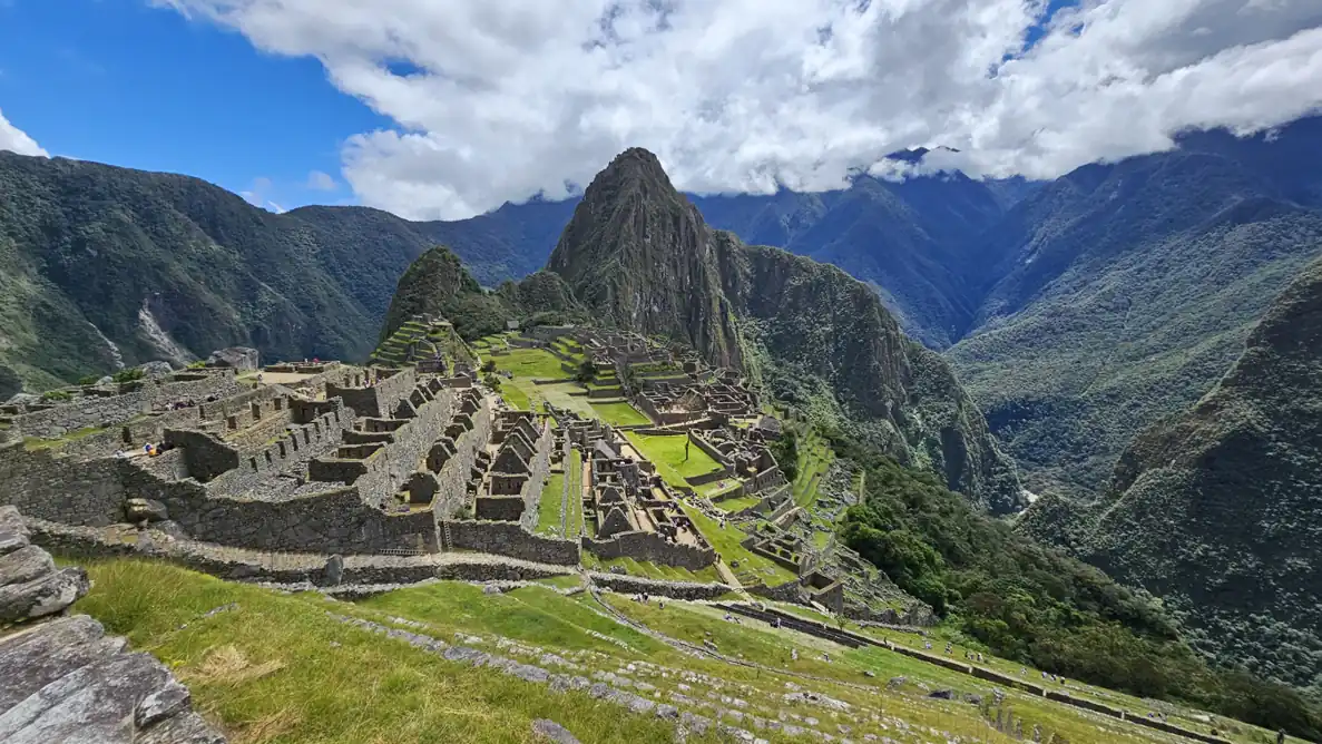
We recognise the mountain skyline. But where did the water between those walls come from, and where did it go? Read Machu Picchu through its slope, fountains, buried construction and human histories.
Follow the terraces across the mountain. Keep the visible wall separate from the material beneath it.
Trace spring, supply channel and fountain. Then ask how excess rainfall left the settlement.
A photograph cannot identify its former residents. Move from buildings to research and local knowledge.
READING 01
In the familiar view of Machu Picchu, the eye moves first to the sharp mountain and then to the green openings among stone buildings. Stay a little longer. The steps across the hillside are more than lines in a photograph. They invite us to consider the slope, soil and rain together. Rather than begin at an emperor’s doorway, let us enter through an ordinary need: where would people find water here, and where would they send it afterwards?
The settlement stands about 2,430 metres above sea level, within the mountain landscape where the Andes meet the upper Amazon basin. UNESCO describes cultural and natural values together. That perspective keeps a wall, a terrace and a passage attached to their hillside. The achievement is not simply being high up. It also lies in the choices that made occupation possible in such a setting. [1]
The timetable of that occupation can change as evidence changes. A programme of AMS radiocarbon dating published in 2021 used bone and teeth from people buried around the site. Its abstract places occupation at approximately 1420–1532 CE. This is neither an opening day nor a date when every building was finished. A new date asks us to reconsider how we know a place was used, rather than merely insert another number into an inherited chronology. [5]
READING 02
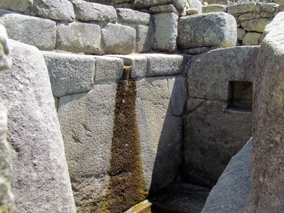
A spring on the mountainside begins one route. Wright’s engineering account follows water through a collection arrangement and a sloping channel to a sequence of fountains. Gravity supplies the movement. At the stone outlet in the photograph, imagine not only its carved form but the controlled release of water arriving from above. A small-looking stream can become part of a settlement’s repeated daily routines. [2]
It is easy to picture a vessel held beneath the falling water. Wright discusses outlets shaped to make filling vessels practical. Yet we do not assign this photograph a fountain number, a named user or a particular ceremony. Alicia Fernández Flórez’s archaeological discussion connects phaqcha with both domestic and sacred purposes. Water’s usefulness and its meanings need not be competing explanations, and one image cannot contain the whole significance of every installation. [2], [4]
The other route begins with rain. On a slope, rainfall can sustain life while accumulated water also burdens the ground. Seeing a supply channel does not mean all water followed it. Bringing spring water to fountains and removing excess water from surfaces and soil are different tasks. Compare the two paths in the reading guide below: one leads towards use, the other towards drainage. It is a conceptual distinction, not a measured plan of every channel. [8]
READING 03
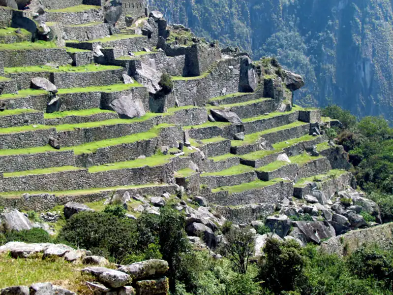
Follow the horizontal edges in the terrace photograph. Stone walls help hold ground on the steep slope and create usable surfaces. But a terrace is not only its visible face. Wright and Valencia describe larger stones, gravel and finer material above as parts of a fill arrangement through which water could move. Those internal layers are not exposed in our photograph. They enter the story through investigation, not through what the camera shows. [3]
Now return to the wider view and think of rain reaching each surface before travelling downwards. Terraces, surface outlets and permeable material below ground address connected problems: how can soil remain in place while excess water passes through? Some of the work supporting a structure is the least conspicuous. The beauty of the green steps can therefore be read alongside the labour of building and maintaining a hillside settlement. [8]
It would nevertheless be misleading to call the supply channel an irrigation channel for all these terraces. Wright and Valencia report finding no irrigation branches from that channel to the agricultural terraces. Nor do they treat surplus domestic fountain water as directly irrigating them. The more rewarding question is not which single extraordinary secret explains everything. It is how several different water tasks could complement one another without becoming the same system in every respect. [3]
READING 04
If a royal estate makes us picture only rulers, everyday life slips outside the frame again. Yale’s institutional account of a 2023 genome study discusses 34 people buried at Machu Picchu alongside comparative samples from Cusco. The individuals associated with service to the royal household had diverse origins extending across regions of the empire. The settlement was not simply an isolated community drawn from its immediate surroundings. [6]
That diversity should not become a romantic story of voluntary travel. The researchers place retainers known as yanacona in the context of Inca forced relocation and resettlement policies. Genetic evidence does not give us every person’s name or feelings. It does, however, help redirect attention towards the people whose work sustained the place. The water and buildings become a deeper human landscape when service and maintenance enter the account. [6]
The claim that Machu Picchu was lost to everyone also leaves people out. José M. Bastante’s study of the records describes Melchor Arteaga guiding Bingham in 1911 and Álvarez and Richarte cultivating terraces. International publicity and local knowledge are different things. Asking who showed the way changes how we tell a familiar discovery story. It lets the people already present in that landscape re-enter the frame instead of treating the mountain as a stage waiting to be found. [7]
Compare the jobs of water without mistaking this conceptual guide for a scale map,complete network or simulation.
In the photograph: The photograph shows an outlet and receiving basin.
Reading with sources: Spring → supply channel → fountains: a conceptual sequence, not a numbered survey of this photograph.
Source 2 ↗In the photograph: Terrace walls and level surfaces are visible.
Reading with sources: Rainfall → surface/ground drainage → discharge. Buried layers are research evidence rather than visible details.
Source 3 ↗In the photograph: The photographs show buildings, not the identity of former residents.
Reading with sources: Genomic research and historical accounts answer different questions about labour and local knowledge.
Source 6 ↗One brings water towards use; drainage moves excess away. Describe the visible falling water before following either function in the sources. [2], [8]
The fill is not visible in this photograph. The engineering study describes material below the surface; do not draw its layers as an observed photo detail. [3]
Arteaga’s guidance and the records of farming distinguish wider publicity from the knowledge of people already using the landscape. [7]
The AMS study concerns people buried at the site. Approximately 1420–1532 CE is an occupation estimate, not a single construction or opening date. [5]
It shows a dated view of a water outlet, not present drinking-water safety or the identity of an ancient user.
The institutional account of the genome study focuses on people associated with service and attendance. Their histories cannot be read directly from a building photograph. [6]
Local guides, cultivators and earlier visitor records complicate that familiar phrase. Worldwide recognition is not the beginning of all knowledge. [7]
The engineering discussion reports no irrigation branches from the supply canal to the terraces. Supply and drainage are not interchangeable. [3]
Fernández discusses differing sacred and domestic functions. No specific ceremony or fountain number has been assigned to our photograph. [4]
Occupation range in the 2021 AMS study, not exact foundation or abandonment days. [5]
Bastante discusses Agustín Lizárraga’s visit and inscription in the records. [7]
Bingham reaches the site with Melchor Arteaga’s guidance; local knowledge precedes publicity. [7]
Yale expedition excavations, part of the collection history of the later dating research. [7]
Inscription on the World Heritage List for cultural and natural values. [1]
Peru’s Ministry of Culture publishes the interdisciplinary research volumes. [4]
Online publication of the new AMS dating study. [5]
Yale publishes its account of the genomic study of the diverse community. [6]
No verified Geçmişin Haritası Machu Picchu Reel or master is available. Continue through the institutional site and research records below. No film has been copied, embedded or playback-tested.
UNESCO site record ↗Original free exercises; no paid Turkish PDF translated or released.
Official landscape description, elevation and 1983 inscription. No current ticket, safety or visitor-condition claims.
Direct page returned 429. Publisher-indexed abstract and fountain section read; gravity supply and vessel-filling described. Full article not read this run; older construction dates not substituted for the AMS estimate.
Official PDF downloaded after web timeout. Selected printed pages 343–347 read locally: terrace layers, drainage and absence of irrigation branches. 2020 reprint of earlier work; no complete book-reading claim.
Official PDF downloaded after web timeout. Selected closing discussion, printed 333–334, read locally: sacred and domestic functions. No particular ritual assigned to the photographed fountain.
Publisher-indexed abstract and metadata read; direct DOI unavailable and Cambridge direct 429. Approximate 1420–1532 CE occupation, online 4 August 2021. Full paper not read.
Institutional account read directly:34 individuals from Machu Picchu and 34 comparisons from Cusco, diverse origins and forced relocation context. Not a reading of the full Science Advances paper.
Official PDF downloaded and selected local-history passages read: Arteaga,Álvarez, Richarte, earlier visits and 1911/1912. Not all 41 PDFpages reviewed; images/maps not copied.
Official university-hosted PDF read in selected water-supply/drainage/terrace sections, printed 25–35. Older numerical assumptions not used; its questions, tables and images not copied.
Original narrative and English edition: Geçmişin Haritası. Sources checked 29 October 2026. Photographs date from 2014 and 2025; they do not establish current visitor conditions or drinking-water safety. Image licences and earlier processing appear with each photograph. Source access is described individually.