Brick
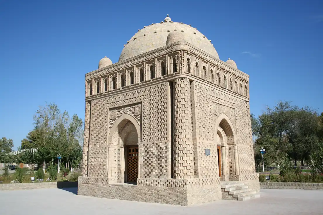
Find a horizontal and a vertical brick course on the mausoleum. Describe the visible rhythm, then use the architectural account to relate the surface to the chamber and dome. A photograph cannot date every brick.[4]
 GEÇMİŞİN
BUKHARA / UZBEKISTAN
Light on brick, reflections on water, roads beneath a dome. What holds a city together? Follow the everyday connections between Bukhara’s different centuries.
Move from the shadow of a brick to a poolside, from trading domes to a household courtyard. Read Bukhara through water, work and knowledge, with photographs and records that belong to different times.
Choose an observation, then follow its evidence.
Find a horizontal and a vertical brick course on the mausoleum. Describe the visible rhythm, then use the architectural account to relate the surface to the chamber and dome. A photograph cannot date every brick.[4]
Follow the pool’s edge towards the surrounding buildings. Match the madrasa and khanqah names to 1568, 1620 and 1622. Separate the date of a building from the date of the photograph.[3]
Look up into Tok-i Sarrafon’s dome. Compare its image record with the separate account of Tim Abdullah Khan. Keep the identity of each building attached to its own evidence.[5]
Late ninth–tenth centuries
An early layer of fired brick and a dome.[4]
Sixteenth–seventeenth centuries
1568, 1620 and 1622 belong to different buildings.[3]
Nineteenth century
Rooms and a courtyard described in a different museum record.[6]
An original comparison guide, not a walking map or a complete list of building phases.
READING 01
You do not have to enter a city through its largest gate to begin understanding it. In Bukhara, start with the distance a single brick projects from a wall. Across the Samanid Mausoleum, horizontal and vertical courses change direction; light settles between their edges and recesses. A surface that seems quiet from far away becomes almost woven when you approach. Let your eye travel slowly across the photograph. Does it reach the dome first, or follow the rhythm being made beneath it?[4]
The building takes us back to the late ninth and early tenth centuries. DKM’s architectural account places its construction within 892–943 and describes fired brick, a square chamber and the transition towards the dome. Here material is more than a background for an applied pattern: construction and the movement across the surface belong to the same architectural thought. Small units make a large volume. The photograph lets us examine that relationship, while its park setting belongs to a much later view of the monument.[4]
Bukhara’s position changed during the dynasty to which the mausoleum belongs. Historian Ramazan Şeşen describes Ismail’s appointment to govern the city in 874. When he became head of the dynasty in 892, he continued to live here, making Bukhara the state’s centre. Political importance and cultural life grew together. The brick building therefore opens onto more than the memory of one ruler: it invites us to ask how a city acquired a new place in a wider world.[2]
READING 02
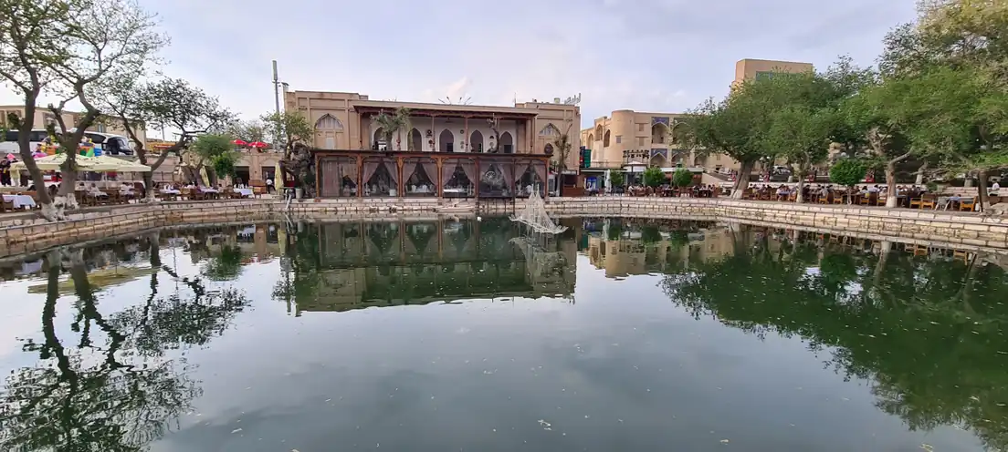
Now turn towards Lyab-i Hauz. Still water makes a second image of the buildings facing it. But treating the pool only as a reflection would leave a basic need of urban life outside our picture. Bukhara’s State Museum-Reserve explains the hauz as an artificial reservoir, storing water when the channels could not supply it. Water availability shaped the daily organisation of the city as well as its architecture. Begin at the stone edge in the photograph, then let your gaze move outwards towards the surrounding buildings.[3]
The museum also connects the shade of trees and the cooler poolside with people gathering there. The space beside the water becomes a place for meeting, waiting and resting. Those are ways of reading the open area between the façades, rather than looking at each façade alone. Notice how water, stone and trees share the same frame. The photograph is dated 12 April 2024; the visible scene cannot establish whether historical water uses continued unchanged or whether this water is suitable for drinking.[3]
Nor did the whole ensemble appear at once. The museum dates Kukeldash Madrasa to 1568, Nadir Divanbegi’s khanqah to 1620 and the madrasa bearing his name to 1622. A madrasa and a khanqah also served different purposes: the latter included accommodation for travelling dervishes. Together they suggest education, hospitality and water in close proximity. Put the three dates beside the three names. Sharing a poolside does not mean sharing a construction year, and those dates should not be turned into an exact date for the pool itself.[3]
READING 03
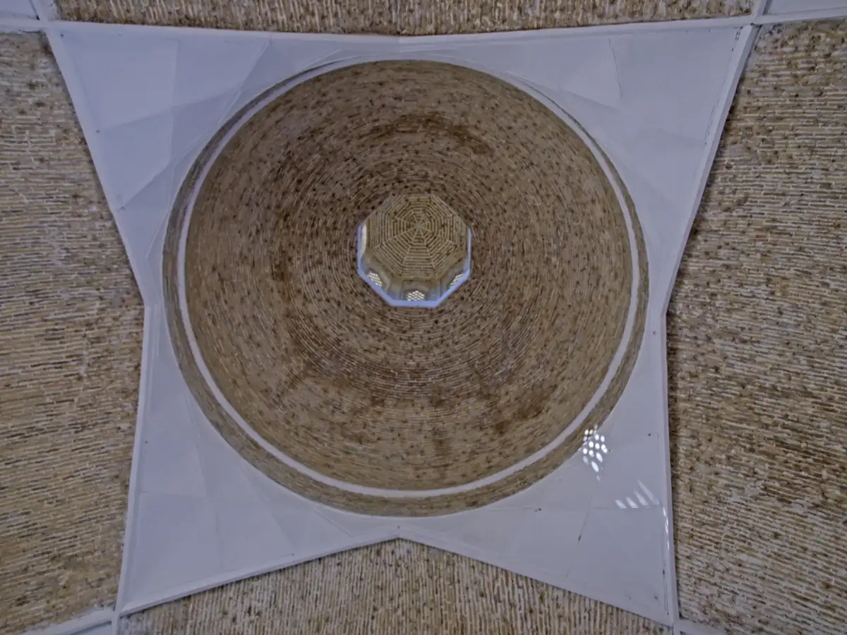
It is easy to picture Bukhara’s commerce as a caravan arriving from far away. Ask a smaller question too: where did exchange settle inside the city, and how did a passage narrow, open or meet another route? UNESCO’s description places historic trading buildings at important crossroads. The name Taki Sarafon recalls moneychangers. Read the dome as a response to intersecting paths, as well as a shape in the skyline. The city’s connections begin to acquire an everyday scale.[1]
Keep two buildings distinct as you investigate. Our upward-looking photograph shows the interior dome of Tok-i Sarrafon. Tim Abdullah Khan is a different covered trading building. The official tourism account dates that tim to the sixteenth century and describes its western entrance and light entering through dome openings. Comparing the records can reveal different answers to similar needs. Transferring one building’s features to the other photograph, however, would erase the very variety we are trying to notice.[5]
Goods were not the only things that travelled. UNESCO’s Silk Roads Programme brings commercial, cultural and scientific exchange into the same field of enquiry. That framework suggests an exercise of our own: follow a piece of cloth together with the skills needed to make it, or a traveller together with the words they carried. This is a question for further research, rather than a documented biography of a particular shop visible today. A city passage can be a starting point for thinking about much larger journeys.[7]
READING 04
Crossing from a monument to a house changes the scale again. The Museum-Reserve’s account of a wealthy merchant’s nineteenth-century home describes a guest room, summer and winter rooms, carved and painted decoration, and an ayvan facing the courtyard. It belonged to a family trading with Russia, Germany and other countries. The outward movement of goods can now be considered alongside the inward arrangement of domestic life. Seasons, hospitality and skilled work become questions to carry through the threshold.[6]
This house reveals the resources of a prosperous household, not the circumstances of every Bukharan. The restored rooms and their displayed clothes, vessels and everyday objects also form a museum interpretation. Ask what work or social setting an object makes visible, as well as whether you find it beautiful. No photograph of the house appears in this story: use the museum record to explore its rooms, rather than searching for that courtyard in our pictures of the pool or trading dome.[6]
Bukhara becomes harder to freeze into one medieval day. UNESCO relates much of the surviving townscape to urban development from the sixteenth century onwards; earlier monuments open onto different times within it. The museum’s city history adds accounts of destruction and renewal, alongside the separate memory carried by legends. Brick, pool, passage and house do not make a stage set completed at a single moment. They reveal a place repeatedly inhabited, remade and remembered. Leave with the connections, and with one date you want to investigate more closely.[1][8]
Begin with the brick courses you can actually see. The architectural account relates fired-brick construction to the square chamber and dome. This does not prove that every visible unit is original or unrestored.[4]
Kukeldash Madrasa: 1568. Nadir Divanbegi’s khanqah: 1620. His madrasa: 1622. The museum distinguishes both dates and functions; it does not make them three names for the same building.[3]
The image record identifies Tok-i Sarrafon. The western entrance and light openings described in the tourism source belong to Tim Abdullah Khan, a separate building.[5]
The museum’s city history recounts a legend in which columns imitating the seven stars of the Great Bear kept the palace standing. Read this as a story of civic memory, not a verified engineering plan.[8]
The early mausoleum, sixteenth- and seventeenth-century townscape and nineteenth-century house belong to different layers. A preserved urban fabric is not a single unchanged day.[1]
A historical account of storing water does not verify present-day water quality. The photographed scene and the reservoir’s earlier function are different kinds of information.[3]
Ismail was appointed to govern Bukhara.[2]
After becoming head of the dynasty, Ismail continued to reside in Bukhara; it became the state’s centre.[2]
The mausoleum’s architectural period; DKM gives a construction range of 892–943.[4]
Kukeldash Madrasa, according to the Museum-Reserve.[3]
Nadir Divanbegi’s khanqah.[3]
Nadir Divanbegi Madrasa.[3]
The period of the wealthy merchant’s house described by the museum.[6]
The historic centre entered UNESCO’s World Heritage List.[1]
No verified Geçmişin Haritası Reel or master film accompanies this Bukhara story. Continue with the UNESCO heritage record ↗ or the Museum-Reserve’s Lyabi-Khauz record ↗.
Open the free Bukhara discovery card ↗
This original free English worksheet is separate from paid products. It is not a translation or release of a paid Turkish PDF.
Historic urban fabric, trading crossroads and 1993 inscription. Preservation does not make all buildings the same age.
Selected historical sections on Samanid government and the city’s position; old population and climate figures are not current data.
Historical reservoir function and separate building dates of 1568, 1620 and 1622. No present-day water quality or opening-hours claim.
Institutional architectural account derived from Meros.uz; brick, square chamber and dome. Broad construction range retained; oldest/first and blanket religious-prohibition claims excluded.
Sixteenth-century covered trading building, western entrance and light openings. It is not the Tok-i Sarrafon building in our photograph.
Nineteenth-century household, seasonal rooms and restored museum display. A wealthy family does not represent all city residents.
Commercial, cultural and scientific exchange as a research framework, not a measured route or a specific shop’s history.
Urban memory, destruction and renewal; the Ark’s seven-star story is identified as a legend, not a construction record.
Original narrative: Geçmişin Haritası. Full English edition and source/licence review: 27 October 2026. Photographs dated 2006, 2015 and 2024 do not establish current visitor conditions.