Plain
Find nearby brickwork, distant towers and greenery in the opening image. UNESCO’s living-landscape description helps connect them; it does not identify the plants in this 2008 photograph. [1]
 GEÇMİŞİN
BAGAN / MYANMAR
Is this plain made only of temples? Follow the brick towers to Ananda’s rising terraces, then listen to a donation recorded in four languages.
4 chapters · 3 licensed photographs · 8 sources
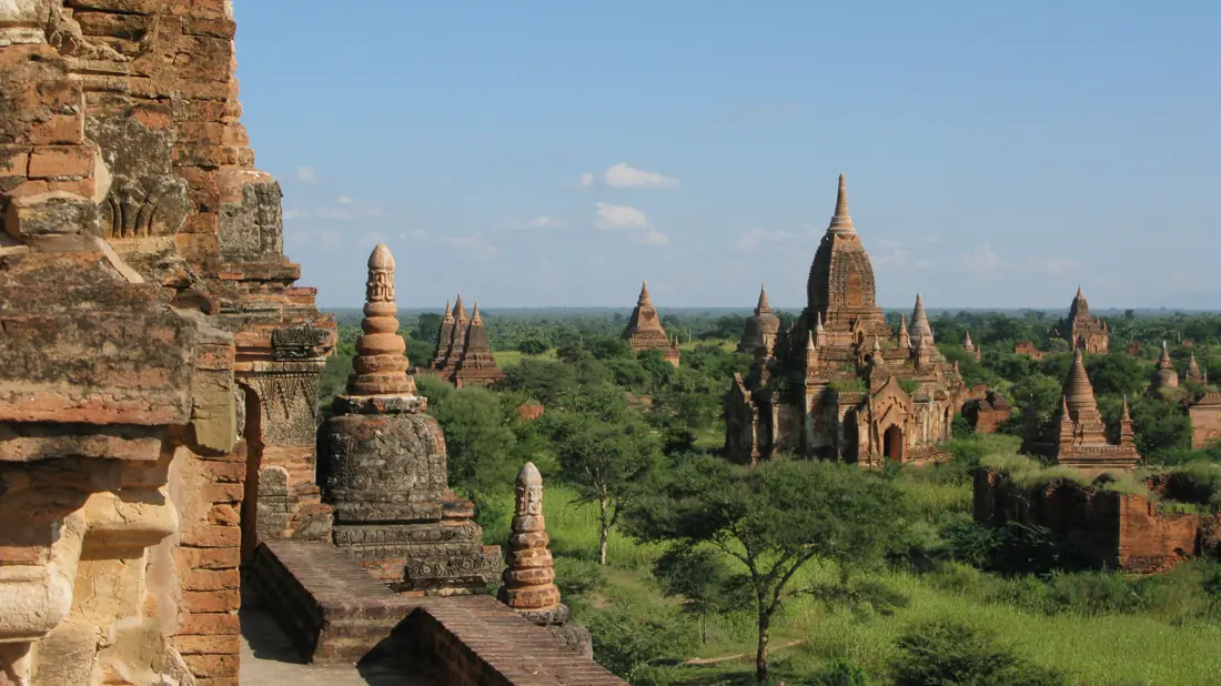
Bagan’s skyline opens onto a living landscape. Three dated photographs lead from the spaces between monuments to architectural storytelling, the Myazedi inscription and the work of caring for fragile traces.
READING 01
Choose the tallest tower in the opening photograph. Now lower your eyes. Green spreads between the buildings; nearby brickwork gives way to smaller silhouettes along the horizon. Stop counting for a moment and follow the intervals. A tower changes when you notice what surrounds it. The plain, usually treated as the background of a postcard, can become one of the story’s leading characters.
Bagan occupies a bend of the Ayeyarwady River in Myanmar’s dry central region. During its prominence between the eleventh and thirteenth centuries, river transport helped connect this centre of power. Buddhist merit-making encouraged donations and construction, with the ruler as a principal donor. A temple therefore made more than devotion visible: wealth and political authority also took shape in brick. [1]
UNESCO describes worship, agriculture and living communities together. The land between monuments belongs to that cultural landscape. Return to one tower among the trees in this photograph, taken in November 2008. Imagine approaching it through its surroundings rather than lifting it out as an isolated jewel. You need not name a crop or identify every building to begin seeing those relationships. [1]
READING 02
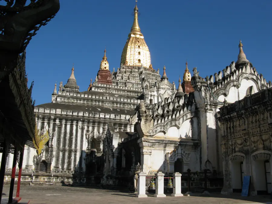
At Ananda, the eye wants to climb. Before reaching the golden spire, trace the steps beneath it: bright walls, shadowed projections, small rising forms. Find three changes of level. The photograph offers a visual walk, drawing attention to the means by which a building leads the gaze upwards.
The Sirindhorn Anthropology Center’s architectural record describes a cruciform arrangement, with sanctuaries and entrance halls opening in four directions around a solid central core. That core supports the tower. Behind the exterior lies an organisation of centre and direction; the photograph is an invitation to investigate it, rather than a complete plan. [2]
A British Library catalogue entry shifts the scale again. Photo 1004/2(691), dated 1908–1909, records an enamelled relief plaque from Ananda and describes Jataka scenes, narratives of the Buddha’s previous lives. Decoration becomes a surface that carries stories. That date belongs to an archival photograph, not the making of the plaque. Our exterior view does not reveal the reliefs in close detail; here the catalogue supplies a different kind of encounter. [3]
READING 03
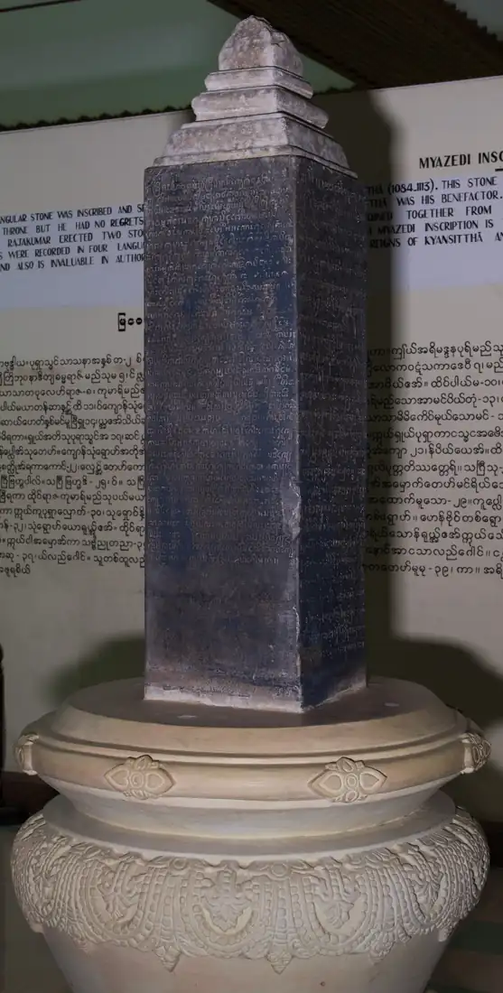
Leave the skyline and approach Myazedi pillar A. On its dark surface, closely spaced lines bring the eye down to the scale of a carved mark. Locate a corner and imagine turning towards another face. Even before deciphering a letter, you can notice how writing occupies the stone. A small object offers another entrance into a wide landscape.
UNESCO’s Memory of the World record identifies four faces carrying Pyu, Mon, Myanmar and Pali. The object addresses us through more than one linguistic window. This photograph, taken in the museum in November 2016, does not display every face; knowing the four languages depends on the institutional record, not on a new reading of the image. [4]
The nomination dossier places a donation in 1113: Prince Rajakumar honoured his father, King Kyansittha, with a golden Buddha image enshrined at Gubyaukgyi. This is a different temple from Ananda. The account also includes villages of enslaved people transferred in the donation. Devotion and unequal power occupy the same record. Of the two closely corresponding pillars, A is in the museum and B is near Myazedi pagoda. [5] Whose name is remembered as the donor, and whose independent voice cannot be heard? Let that question travel back with you into the plain.
READING 04
Why should a crack in brick endanger a painted colour? After the earthquake of 24 August 2016, researchers from Tokyo investigated murals in Bagan between 24 and 30 September. Their report connected movement in masonry with damage to the plaster carrying paintings. Different materials and techniques suffered differently; some earlier repair materials had also created problems. The report describes that investigation, not a present-day diagnosis made from our photographs. [7]
Getty’s conservation project likewise investigates how different building types behave in earthquakes. Modelling and testing help develop appropriate, limited interventions. Decorated surfaces are considered alongside donor attribution, architectural meaning and continuing religious use. Documentation is part of the work: keeping information can be as consequential as stabilising a visible surface. [6]
The 2019 World Heritage decision recommended further research into Bagan’s historical water management and a landscape approach to care. A recommendation is not evidence that every task has since been completed. [8] Look across the plain once more. A tower holds the labour of particular people; an inscription preserves a donation while leaving other lives only partly visible. Reading those connections gives the beautiful silhouette another dimension.
Find a detail first; then connect it to its source.
Find nearby brickwork, distant towers and greenery in the opening image. UNESCO’s living-landscape description helps connect them; it does not identify the plants in this 2008 photograph. [1]
Follow three steps upwards on Ananda’s exterior. The architectural record explains a four-directional plan, which this single exterior view cannot show in full. [2]
Find lines and a corner on Myazedi A. The four languages come from the UNESCO record; no language is assigned here to the face visible in this photograph. [4]
Identify the donation, its date and its temple in the dossier. Keep event and photograph apart. [5]
Pyu, Mon, Myanmar and Pali share one four-faced monument. This is a guide to the institutional description, not a fresh translation of the inscription. [4]
Whose generosity is commemorated, and whose lives are subjected to it? Look beyond the named donor. [5]
The open spaces belong to a living cultural landscape. A dated photograph does not establish the crop, land use or condition of the same place in 2026. [1]
The exterior photograph and the separately catalogued Jataka-plaque photograph offer different views. The archival date 1908–1909 must not become a construction date. [3]
Check the A/B distinction in the dossier. Keep the photographed pillar and the separately named temples apart. [5]
The architectural record relates a tradition about the mythical Nandamula cave. That story is not proof of a surveyed physical model or a measured copy. [2]
The heritage record distinguishes different ages, materials, designs and repair histories. The skyline cannot make every surface an unchanged survivor of the eleventh to thirteenth centuries. [1]
No. The image emphasises one face. The four-language identification comes from UNESCO’s description; we make no new decipherment claim. [4]
Bagan’s prominence as a regional imperial centre. [1]
Date of the donation recorded by the Myazedi inscription. [5]
Discovery dates reported for the two pillars in the nomination dossier. [5]
Date of the British Library’s Ananda-plaque photograph record, not the plaque’s manufacture. [3]
Myazedi entered UNESCO’s Memory of the World register. [4]
Earthquake; the Tokyo institute’s field investigation followed on 24–30 September. [7]
Start of Getty’s Bagan Conservation Project. [6]
Bagan was inscribed on the World Heritage List. [8]
UNESCO’s Bagan record ↗ · Getty’s conservation project ↗
No verified Geçmişin Haritası Bagan Reel or master film accompanies this story. These are reading links; no video has been copied or embedded.
Open the free four-question discovery card ↗
Original free English worksheet, separate from paid products; not a translation or release of a paid Turkish PDF.
Outstanding Universal Value and authenticity: river transport, merit-making, living landscape.
Chedha Tingsanchali’s architectural record and mythical cave tradition; institutional images are not reproduced.
Photo 1004/2(691), 1908–1909: catalogue description only; the archival image itself was not inspected.
Four languages and faces; registration in 2015. No new decipherment or oldest-inscription claim.
Selected identity and A/B passages, and donation context on printed pages 7–8; not a new translation from the four original languages.
Project background, repair typologies, decorated elements and documentation; not every technical report or current monument condition.
Yoshifumi Maekawa’s dated 2016 report; official indexed text read after direct-page timeout. No 2026 field diagnosis.
Inscription decision and recommendations; completion of the recommended work is not claimed.
Original narrative and English edition: Geçmişin Haritası. Source records checked 27 October 2026. Photographs retain their 2008 and 2016 dates; 1113 dates the inscription’s donation record. These photographs do not establish present access or condition.